Hopelchén geodata
Hopelchén (Campeche) is a seat of a second-order administrative division; located in Mexico in America/Merida (GMT-6) time zone. With population of 7,295 people, there are 1268 cities with bigger population in this country. Compared to other cities in Mexico, 51.4% of cities are located further ↓South; 97.7% of cities are located further ←West and 80.5% of cities have higher elevation than Hopelchén. Note1


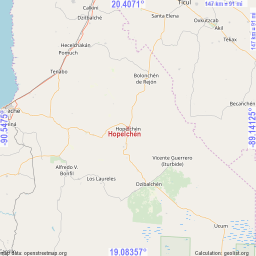
Hopelchén GPS coordinates[2]
19° 44' 48.156" North, 89° 50' 39.732" West
| Map corner | latitude | longitude |
|---|---|---|
| Upper-left | 20.4071°, | -90.5475° |
| Center: | 19.74671°, | -89.84437° |
| Lower-right: | 19.08357°, | -89.14125° |
| Map W x H: | 147.2×147.2 km | = 91.5×91.5mi |
| max Lat: | 32.7° ⇑48.6% North |
| Hopelchén: | 19.74671° |
| min Lat: | ⇓51.4% South 14.53588° |
| min Long | Hopelchén | max Long |
| -117.105° | -89.84437° | -86.73105° |
| W 97.7%⇐ | ⇒2.3% E |
Elevation
Elevation of Hopelchén is 88 m = 289 ft, and this is 1165.7 m = 3824 ft below average elevation for this country.
| Max E: |
3497 m = 11473 ft | 80.5% |
| Avg. | 1253.7 m = 4113 ft | |
| Hopelchén | 88 m = 289 ft | |
Min E: |
-1 m = -3 ft | 19.5% |
See also: Mexico elevation on elevation.city.
Geographical zone
Hopelchén is located in North Torrid zone (between Equator and Tropic of Cancer). Distance of this Northern Tropic circle is 410.3 km =254.9 mi to North.| Distance of | km | miles | from Hopelchén |
|---|---|---|---|
| North Pole | 7811.4 | 4853.8 | to North |
| Arctic Circle | 5205.5 | 3234.5 | to North |
| Tropic Cancer | 410.3 | 254.9 | to North |
| Equator | 2195.6 | 1364.3 | to South |


Nearby cities:
15 places around Hopelchén: (largest is in red/bold)
• Alfredo V. Bonfil
42.8 km =26.6 mi,  235°
235°
• Bolonchén de Rejón
30.4 km =18.9 mi,  19°
19°
• Crucero San Luis
16.1 km =10 mi,  250°
250°
• Dzibalchén
34.2 km =21.3 mi,  159°
159°
• Ich-Ek
12.9 km =8 mi,  263°
263°
• Iturbide
31.5 km =19.6 mi,  126°
126°
• Konchén
17 km =10.6 mi,  182°
182°
• Los Laureles
32.8 km =20.4 mi,  208°
208°
• Nahalal
40.5 km =25.2 mi,  350°
350°
• Pich
40.8 km =25.4 mi,  224°
224°
• Quetzal Edzná
42.1 km =26.2 mi, 220°
• Santa Rita
11 km =6.8 mi,  194°
194°
• Suc-Tuc
20.6 km =12.8 mi, 259°
• Tikinmul
39.7 km =24.7 mi,  273°
273°
• Xcupil
9.1 km =5.7 mi, 189°
Sources, notices
• [Note1] Compared only with cities in Mexico existing in our database
• [Src1] Map data: © OpenStreetMap contributors (CC-BY-SA)
• [Src2] Other city data from geonames.org with taken over terms of usage.
• [Src3] Geographical zone / Annual Mean Temperature by Robert A. Rohde @ Wikipedia
