Las Compuertas geodata
Las Compuertas (Guerrero) is a populated place; located in Mexico in America/Mexico_City (GMT-6) time zone. With population of 1,101 people, there are 7901 cities with bigger population in this country. Compared to other cities in Mexico, 86.6% of cities are located further ↑North; 64.1% of cities are located further →East and 61.7% of cities have higher elevation than Las Compuertas. Note1


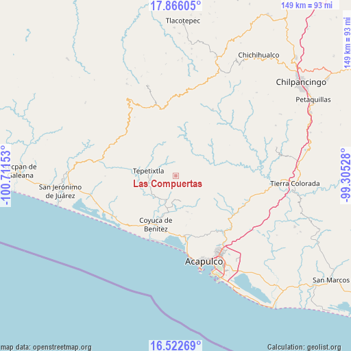
Las Compuertas GPS coordinates[2]
17° 11' 44.124" North, 100° 0' 30.24" West
| Map corner | latitude | longitude |
|---|---|---|
| Upper-left | 17.86605°, | -100.71153° |
| Center: | 17.19559°, | -100.0084° |
| Lower-right: | 16.52269°, | -99.30528° |
| Map W x H: | 149.4×149.4 km | = 92.8×92.8mi |
| max Lat: | 32.7° ⇑86.6% North |
| Las Compuertas: | 17.19559° |
| min Lat: | ⇓13.4% South 14.53588° |
| min Long | Las Compuertas | max Long |
| -117.105° | -100.0084° | -86.73105° |
| W 35.9%⇐ | ⇒64.1% E |
Elevation
Elevation of Las Compuertas is 900 m = 2953 ft, and this is 353.7 m = 1160 ft below average elevation for this country.
| Max E: |
3497 m = 11473 ft | 61.7% |
| Avg. | 1253.7 m = 4113 ft | |
| Las Compuertas | 900 m = 2953 ft | |
Min E: |
-1 m = -3 ft | 38.3% |
See also: Mexico elevation on elevation.city.
Geographical zone
Las Compuertas is located in North Torrid zone (between Equator and Tropic of Cancer). Distance of this Northern Tropic circle is 693.9 km =431.2 mi to North.| Distance of | km | miles | from Las Compuertas |
|---|---|---|---|
| North Pole | 8095.1 | 5030.1 | to North |
| Arctic Circle | 5489.2 | 3410.8 | to North |
| Tropic Cancer | 693.9 | 431.2 | to North |
| Equator | 1912 | 1188.1 | to South |


Nearby cities:
15 places around Las Compuertas: (largest is in red/bold)
• Agua Zarca
17.6 km =10.9 mi,  156°
156°
• Aguas Blancas
18.6 km =11.6 mi,  198°
198°
• Barrio Nuevo del Progreso
7.4 km =4.6 mi,  296°
296°
• Carrera Larga
19.5 km =12.1 mi,  209°
209°
• Coyuca de Benítez
22.4 km =13.9 mi, 201°
• La Providencia
23.1 km =14.4 mi,  118°
118°
• Ocotillo
22.6 km =14 mi,  141°
141°
• Platanillo
17.9 km =11.1 mi, 144°
• Pueblo Viejo
11.1 km =6.9 mi,  168°
168°
• San Cristóbal
11.5 km =7.1 mi,  39°
39°
• San Juan del Río
19.5 km =12.1 mi, 161°
• Santa Rosa de Lima
15.8 km =9.8 mi,  73°
73°
• Tepetixtla
11.8 km =7.3 mi,  280°
280°
• Tixtlancingo
16.1 km =10 mi, 162°
• Yetla
22.5 km =14 mi,  178°
178°
Sources, notices
• [Note1] Compared only with cities in Mexico existing in our database
• [Src1] Map data: © OpenStreetMap contributors (CC-BY-SA)
• [Src2] Other city data from geonames.org with taken over terms of usage.
• [Src3] Geographical zone / Annual Mean Temperature by Robert A. Rohde @ Wikipedia
