Yetlancingo geodata
Yetlancingo (Guerrero) is a populated place; located in Mexico in America/Mexico_City (GMT-6) time zone. With population of 1,169 people, there are 7428 cities with bigger population in this country. Compared to other cities in Mexico, 81.1% of cities are located further ↑North; 51.3% of cities are located further →East and 56.6% of cities have lower elevation than Yetlancingo. Note1


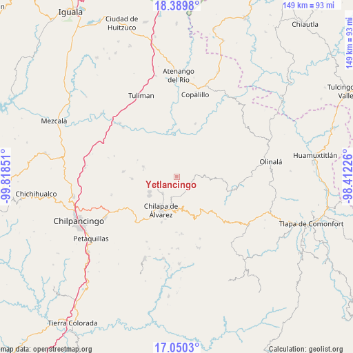
Yetlancingo GPS coordinates[2]
17° 43' 16.68" North, 99° 6' 55.368" West
| Map corner | latitude | longitude |
|---|---|---|
| Upper-left | 18.3898°, | -99.81851° |
| Center: | 17.7213°, | -99.11538° |
| Lower-right: | 17.0503°, | -98.41226° |
| Map W x H: | 148.9×148.9 km | = 92.5×92.5mi |
| max Lat: | 32.7° ⇑81.1% North |
| Yetlancingo: | 17.7213° |
| min Lat: | ⇓18.9% South 14.53588° |
| min Long | Yetlancingo | max Long |
| -117.105° | -99.11538° | -86.73105° |
| W 48.7%⇐ | ⇒51.3% E |
Elevation
Elevation of Yetlancingo is 1640 m = 5381 ft, and this is 386.3 m = 1267 ft above average elevation for this country.
| Max E: |
3497 m = 11473 ft | 43.4% |
| Yetlancingo | 1640 m 5381 ft | |
| Avg. | 1253.7 m = 4113 ft | |
Min E: |
-1 m = -3 ft | 56.6% |
See also: Mexico elevation on elevation.city.
Geographical zone
Yetlancingo is located in North Torrid zone (between Equator and Tropic of Cancer). Distance of this Northern Tropic circle is 635.5 km =394.9 mi to North.| Distance of | km | miles | from Yetlancingo |
|---|---|---|---|
| North Pole | 8036.6 | 4993.7 | to North |
| Arctic Circle | 5430.8 | 3374.5 | to North |
| Tropic Cancer | 635.5 | 394.9 | to North |
| Equator | 1970.4 | 1224.3 | to South |


Nearby cities:
15 places around Yetlancingo: (largest is in red/bold)
• Acatlán
9.1 km =5.7 mi,  219°
219°
• Ajuatetla
8 km =5 mi,  32°
32°
• Las Trancas
11.7 km =7.3 mi,  261°
261°
• Los Magueyes
12 km =7.5 mi,  209°
209°
• Mazatepec
12.5 km =7.8 mi,  239°
239°
• Nejapa
12.3 km =7.6 mi,  194°
194°
• Oztotitlán
11 km =6.8 mi,  119°
119°
• Pantitlán
9.1 km =5.7 mi,  176°
176°
• San Juan (Las Joyas)
12.2 km =7.6 mi,  24°
24°
• Santa Catarina (Santa Catarina las Joyas)
4.1 km =2.5 mi,  38°
38°
• Santa Cruz
8 km =5 mi, 182°
• Tecoanapa
9.2 km =5.7 mi, 124°
• Tlalcomulco
8 km =5 mi,  100°
100°
• Tlaltempanapa
6.8 km =4.2 mi,  284°
284°
• Zitlala
8.3 km =5.2 mi,  245°
245°
Sources, notices
• [Note1] Compared only with cities in Mexico existing in our database
• [Src1] Map data: © OpenStreetMap contributors (CC-BY-SA)
• [Src2] Other city data from geonames.org with taken over terms of usage.
• [Src3] Geographical zone / Annual Mean Temperature by Robert A. Rohde @ Wikipedia
