Ajuatetla geodata
Ajuatetla (Guerrero) is a populated place; located in Mexico in America/Mexico_City (GMT-6) time zone. With population of 558 people, there are 15286 cities with bigger population in this country. Compared to other cities in Mexico, 80.7% of cities are located further ↑North; 50.8% of cities are located further →East and 51.4% of cities have higher elevation than Ajuatetla. Note1


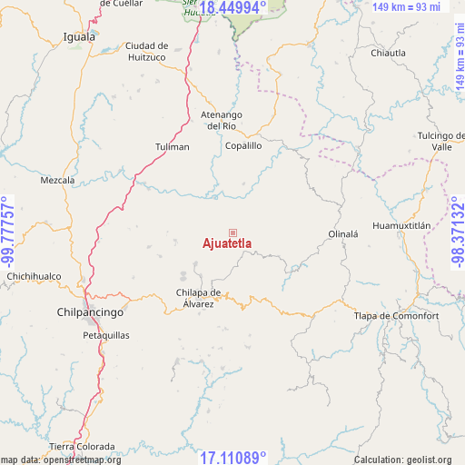
Ajuatetla GPS coordinates[2]
17° 46' 54.012" North, 99° 4' 27.984" West
| Map corner | latitude | longitude |
|---|---|---|
| Upper-left | 18.44994°, | -99.77757° |
| Center: | 17.78167°, | -99.07444° |
| Lower-right: | 17.11089°, | -98.37132° |
| Map W x H: | 148.9×148.9 km | = 92.5×92.5mi |
| max Lat: | 32.7° ⇑80.7% North |
| Ajuatetla: | 17.78167° |
| min Lat: | ⇓19.3% South 14.53588° |
| min Long | Ajuatetla | max Long |
| -117.105° | -99.07444° | -86.73105° |
| W 49.2%⇐ | ⇒50.8% E |
Elevation
Elevation of Ajuatetla is 1363 m = 4472 ft, and this is 109.3 m = 359 ft above average elevation for this country.
| Max E: |
3497 m = 11473 ft | 51.4% |
| Ajuatetla | 1363 m 4472 ft | |
| Avg. | 1253.7 m = 4113 ft | |
Min E: |
-1 m = -3 ft | 48.6% |
See also: Mexico elevation on elevation.city.
Geographical zone
Ajuatetla is located in North Torrid zone (between Equator and Tropic of Cancer). Distance of this Northern Tropic circle is 628.8 km =390.7 mi to North.| Distance of | km | miles | from Ajuatetla |
|---|---|---|---|
| North Pole | 8029.9 | 4989.5 | to North |
| Arctic Circle | 5424 | 3370.3 | to North |
| Tropic Cancer | 628.8 | 390.7 | to North |
| Equator | 1977.1 | 1228.5 | to South |


Nearby cities:
15 places around Ajuatetla: (largest is in red/bold)
• Mitlancingo
11.3 km =7 mi,  61°
61°
• Ostoyahualco
13.5 km =8.4 mi,  123°
123°
• Oztotitlán
13.3 km =8.3 mi,  156°
156°
• Rincón de Cozahuapa
14.2 km =8.8 mi,  68°
68°
• San Juan (Las Joyas)
4.4 km =2.7 mi,  10°
10°
• Santa Catarina (Santa Catarina las Joyas)
4 km =2.5 mi,  206°
206°
• Santa Cruz
15.4 km =9.6 mi,  197°
197°
• Tecoanapa
12.3 km =7.6 mi, 164°
• Tecolcuautla
13.4 km =8.3 mi,  87°
87°
• Tepetlatipa
5.9 km =3.7 mi, 62°
• Tlalcomulco
8.9 km =5.5 mi, 156°
• Tlalcozotitlán
12.8 km =8 mi,  332°
332°
• Tlaltempanapa
12 km =7.5 mi,  245°
245°
• Xocoyolzintla
12.4 km =7.7 mi,  128°
128°
• Yetlancingo
8 km =5 mi, 212°
Sources, notices
• [Note1] Compared only with cities in Mexico existing in our database
• [Src1] Map data: © OpenStreetMap contributors (CC-BY-SA)
• [Src2] Other city data from geonames.org with taken over terms of usage.
• [Src3] Geographical zone / Annual Mean Temperature by Robert A. Rohde @ Wikipedia
