Tecoanapa geodata
Tecoanapa (Guerrero) is a populated place; located in Mexico in America/Mexico_City (GMT-6) time zone. With population of 758 people, there are 11551 cities with bigger population in this country. Compared to other cities in Mexico, 81.5% of cities are located further ↑North; 50.4% of cities are located further →East and 57% of cities have higher elevation than Tecoanapa. Note1


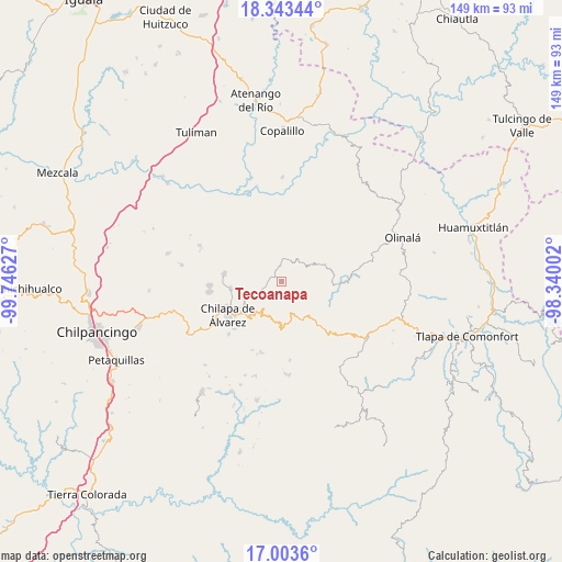
Tecoanapa GPS coordinates[2]
17° 40' 29.172" North, 99° 2' 35.304" West
| Map corner | latitude | longitude |
|---|---|---|
| Upper-left | 18.34344°, | -99.74627° |
| Center: | 17.67477°, | -99.04314° |
| Lower-right: | 17.0036°, | -98.34002° |
| Map W x H: | 149×149 km | = 92.6×92.6mi |
| max Lat: | 32.7° ⇑81.5% North |
| Tecoanapa: | 17.67477° |
| min Lat: | ⇓18.5% South 14.53588° |
| min Long | Tecoanapa | max Long |
| -117.105° | -99.04314° | -86.73105° |
| W 49.6%⇐ | ⇒50.4% E |
Elevation
Elevation of Tecoanapa is 1122 m = 3681 ft, and this is 131.7 m = 432 ft below average elevation for this country.
| Max E: |
3497 m = 11473 ft | 57% |
| Avg. | 1253.7 m = 4113 ft | |
| Tecoanapa | 1122 m = 3681 ft | |
Min E: |
-1 m = -3 ft | 43% |
See also: Mexico elevation on elevation.city.
Geographical zone
Tecoanapa is located in North Torrid zone (between Equator and Tropic of Cancer). Distance of this Northern Tropic circle is 640.7 km =398.1 mi to North.| Distance of | km | miles | from Tecoanapa |
|---|---|---|---|
| North Pole | 8041.8 | 4996.9 | to North |
| Arctic Circle | 5435.9 | 3377.7 | to North |
| Tropic Cancer | 640.7 | 398.1 | to North |
| Equator | 1965.3 | 1221.2 | to South |


Nearby cities:
15 places around Tecoanapa: (largest is in red/bold)
• Acatlán
13.5 km =8.4 mi,  262°
262°
• Ahuacuotzingo
12.3 km =7.6 mi,  69°
69°
• Ajuatetla
12.3 km =7.6 mi,  344°
344°
• Nejapa
12.7 km =7.9 mi,  237°
237°
• Ostoyahualco
9.2 km =5.7 mi,  60°
60°
• Oztotitlán
2 km =1.2 mi,  97°
97°
• Pantitlán
8.1 km =5 mi, 241°
• Petatlán
11.9 km =7.4 mi,  151°
151°
• Santa Catarina (Santa Catarina las Joyas)
9.8 km =6.1 mi,  328°
328°
• Santa Cruz
8.5 km =5.3 mi,  250°
250°
• Tepozonalco
11.4 km =7.1 mi,  173°
173°
• Tlalcomulco
3.8 km =2.4 mi,  3°
3°
• Xocoyolzintla
7.7 km =4.8 mi, 56°
• Yetlancingo
9.2 km =5.7 mi,  304°
304°
• Zompeltepec
12.9 km =8 mi,  189°
189°
Sources, notices
• [Note1] Compared only with cities in Mexico existing in our database
• [Src1] Map data: © OpenStreetMap contributors (CC-BY-SA)
• [Src2] Other city data from geonames.org with taken over terms of usage.
• [Src3] Geographical zone / Annual Mean Temperature by Robert A. Rohde @ Wikipedia
