Los Magueyitos geodata
Los Magueyitos (Guerrero) is a populated place; located in Mexico in America/Mexico_City (GMT-6) time zone. With population of 783 people, there are 11148 cities with bigger population in this country. Compared to other cities in Mexico, 88% of cities are located further ↑North; 53.8% of cities are located further →East and 62% of cities have higher elevation than Los Magueyitos. Note1


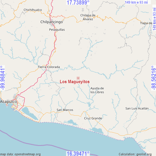
Los Magueyitos GPS coordinates[2]
17° 4' 5.016" North, 99° 15' 55.008" West
| Map corner | latitude | longitude |
|---|---|---|
| Upper-left | 17.73899°, | -99.96841° |
| Center: | 17.06806°, | -99.26528° |
| Lower-right: | 16.39471°, | -98.56216° |
| Map W x H: | 149.5×149.5 km | = 92.9×92.9mi |
| max Lat: | 32.7° ⇑88% North |
| Los Magueyitos: | 17.06806° |
| min Lat: | ⇓12% South 14.53588° |
| min Long | Los Magueyitos | max Long |
| -117.105° | -99.26528° | -86.73105° |
| W 46.2%⇐ | ⇒53.8% E |
Elevation
Elevation of Los Magueyitos is 881 m = 2890 ft, and this is 372.7 m = 1223 ft below average elevation for this country.
| Max E: |
3497 m = 11473 ft | 62% |
| Avg. | 1253.7 m = 4113 ft | |
| Los Magueyitos | 881 m = 2890 ft | |
Min E: |
-1 m = -3 ft | 38% |
See also: Mexico elevation on elevation.city.
Geographical zone
Los Magueyitos is located in North Torrid zone (between Equator and Tropic of Cancer). Distance of this Northern Tropic circle is 708.1 km =440 mi to North.| Distance of | km | miles | from Los Magueyitos |
|---|---|---|---|
| North Pole | 8109.3 | 5038.9 | to North |
| Arctic Circle | 5503.4 | 3419.7 | to North |
| Tropic Cancer | 708.1 | 440 | to North |
| Equator | 1897.8 | 1179.2 | to South |


Nearby cities:
15 places around Los Magueyitos: (largest is in red/bold)
• Apantla
10.7 km =6.6 mi,  107°
107°
• Buenavista de Allende
9.3 km =5.8 mi,  143°
143°
• Colotepec
6.3 km =3.9 mi,  118°
118°
• El Charco
1.5 km =0.9 mi,  235°
235°
• El Refugio
7.6 km =4.7 mi, 115°
• El Tabacal
9.7 km =6 mi,  301°
301°
• El Terrero
10.7 km =6.6 mi,  305°
305°
• Lagunillas
9.5 km =5.9 mi,  128°
128°
• Los Saucitos
9.9 km =6.2 mi,  201°
201°
• Los Tepetates
2.2 km =1.4 mi, 117°
• Mecatepec
9.8 km =6.1 mi,  162°
162°
• San Francisco
7.2 km =4.5 mi, 195°
• Tecoanapa
9 km =5.6 mi,  176°
176°
• Tecuantepec
7.7 km =4.8 mi,  166°
166°
• Xalpatláhuac
8.5 km =5.3 mi,  234°
234°
Sources, notices
• [Note1] Compared only with cities in Mexico existing in our database
• [Src1] Map data: © OpenStreetMap contributors (CC-BY-SA)
• [Src2] Other city data from geonames.org with taken over terms of usage.
• [Src3] Geographical zone / Annual Mean Temperature by Robert A. Rohde @ Wikipedia
