Xochitepec geodata
Xochitepec (Guerrero) is a populated place; located in Mexico in America/Mexico_City (GMT-6) time zone. With population of 1,356 people, there are 6414 cities with bigger population in this country. Compared to other cities in Mexico, 86.8% of cities are located further ↑North; 53.2% of cities are located further →East and 65.4% of cities have higher elevation than Xochitepec. Note1


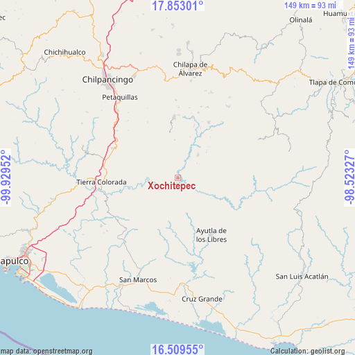
Xochitepec GPS coordinates[2]
17° 10' 57" North, 99° 13' 35.004" West
| Map corner | latitude | longitude |
|---|---|---|
| Upper-left | 17.85301°, | -99.92952° |
| Center: | 17.1825°, | -99.22639° |
| Lower-right: | 16.50955°, | -98.52327° |
| Map W x H: | 149.4×149.4 km | = 92.8×92.8mi |
| max Lat: | 32.7° ⇑86.8% North |
| Xochitepec: | 17.1825° |
| min Lat: | ⇓13.2% South 14.53588° |
| min Long | Xochitepec | max Long |
| -117.105° | -99.22639° | -86.73105° |
| W 46.8%⇐ | ⇒53.2% E |
Elevation
Elevation of Xochitepec is 667 m = 2188 ft, and this is 586.7 m = 1925 ft below average elevation for this country.
| Max E: |
3497 m = 11473 ft | 65.4% |
| Avg. | 1253.7 m = 4113 ft | |
| Xochitepec | 667 m = 2188 ft | |
Min E: |
-1 m = -3 ft | 34.6% |
See also: Mexico elevation on elevation.city.
Geographical zone
Xochitepec is located in North Torrid zone (between Equator and Tropic of Cancer). Distance of this Northern Tropic circle is 695.4 km =432.1 mi to North.| Distance of | km | miles | from Xochitepec |
|---|---|---|---|
| North Pole | 8096.5 | 5030.9 | to North |
| Arctic Circle | 5490.7 | 3411.8 | to North |
| Tropic Cancer | 695.4 | 432.1 | to North |
| Equator | 1910.5 | 1187.1 | to South |


Nearby cities:
15 places around Xochitepec: (largest is in red/bold)
• Acalmani
15.7 km =9.8 mi,  132°
132°
• Colotepec
15.8 km =9.8 mi,  174°
174°
• El Charco
14.6 km =9.1 mi,  201°
201°
• El Refugio
16.3 km =10.1 mi, 170°
• El Tabacal
14.6 km =9.1 mi,  238°
238°
• El Tejoruco
12.7 km =7.9 mi,  59°
59°
• El Terrero
14.5 km =9 mi, 243°
• Los Magueyitos
13.4 km =8.3 mi, 197°
• Los Tepetates
13.9 km =8.6 mi,  189°
189°
• Nacaxtlán
8 km =5 mi,  283°
283°
• Plan de Gatica
12.6 km =7.8 mi,  117°
117°
• Pueblo Viejo
7 km =4.3 mi,  314°
314°
• San José
15.8 km =9.8 mi,  48°
48°
• Santa Cruz
14.8 km =9.2 mi,  344°
344°
• Teozintla
13.1 km =8.1 mi,  40°
40°
Sources, notices
• [Note1] Compared only with cities in Mexico existing in our database
• [Src1] Map data: © OpenStreetMap contributors (CC-BY-SA)
• [Src2] Other city data from geonames.org with taken over terms of usage.
• [Src3] Geographical zone / Annual Mean Temperature by Robert A. Rohde @ Wikipedia
