El Carmen geodata
El Carmen (Guerrero) is a populated place; located in Mexico in America/Mexico_City (GMT-6) time zone. With population of 1,282 people, there are 6760 cities with bigger population in this country. Compared to other cities in Mexico, 89.6% of cities are located further ↑North; 60.7% of cities are located further ←West and 64.1% of cities have higher elevation than El Carmen. Note1


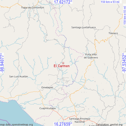
El Carmen GPS coordinates[2]
16° 57' 1.296" North, 98° 14' 15.504" West
| Map corner | latitude | longitude |
|---|---|---|
| Upper-left | 17.62172°, | -98.94077° |
| Center: | 16.95036°, | -98.23764° |
| Lower-right: | 16.27659°, | -97.53452° |
| Map W x H: | 149.6×149.6 km | = 93×93mi |
| max Lat: | 32.7° ⇑89.6% North |
| El Carmen: | 16.95036° |
| min Lat: | ⇓10.4% South 14.53588° |
| min Long | El Carmen | max Long |
| -117.105° | -98.23764° | -86.73105° |
| W 60.7%⇐ | ⇒39.3% E |
Elevation
Elevation of El Carmen is 743 m = 2438 ft, and this is 510.7 m = 1676 ft below average elevation for this country.
| Max E: |
3497 m = 11473 ft | 64.1% |
| Avg. | 1253.7 m = 4113 ft | |
| El Carmen | 743 m = 2438 ft | |
Min E: |
-1 m = -3 ft | 35.9% |
See also: Mexico elevation on elevation.city.
Geographical zone
El Carmen is located in North Torrid zone (between Equator and Tropic of Cancer). Distance of this Northern Tropic circle is 721.2 km =448.1 mi to North.| Distance of | km | miles | from El Carmen |
|---|---|---|---|
| North Pole | 8122.4 | 5047 | to North |
| Arctic Circle | 5516.5 | 3427.8 | to North |
| Tropic Cancer | 721.2 | 448.1 | to North |
| Equator | 1884.7 | 1171.1 | to South |


Nearby cities:
15 places around El Carmen: (largest is in red/bold)
• Arroyo Prieto
15.7 km =9.8 mi,  329°
329°
• El Coyul
12.1 km =7.5 mi,  352°
352°
• Guadalupe Mano de León
9.6 km =6 mi,  132°
132°
• Jicayán de Tovar
19.7 km =12.2 mi,  0°
0°
• La Soledad
8.2 km =5.1 mi,  114°
114°
• La Trinidad
14.8 km =9.2 mi,  22°
22°
• Rancho Viejo (Rancho Nuevo de la Democracia)
9.3 km =5.8 mi,  9°
9°
• Río Encajonado
13 km =8.1 mi,  321°
321°
• San Jerónimo
15.4 km =9.6 mi,  238°
238°
• San Pedro Cuitlapan
2.9 km =1.8 mi, 329°
• Santa Cruz Yucucani
19.3 km =12 mi,  43°
43°
• Terrero Venado
10.7 km =6.6 mi,  264°
264°
• Tlacoachistlahuaca
16.9 km =10.5 mi,  203°
203°
• Xochistlahuaca
17.3 km =10.7 mi,  181°
181°
• Yoloxóchitl (Santiago Yoloxóchitl)
6.4 km =4 mi, 15°
Sources, notices
• [Note1] Compared only with cities in Mexico existing in our database
• [Src1] Map data: © OpenStreetMap contributors (CC-BY-SA)
• [Src2] Other city data from geonames.org with taken over terms of usage.
• [Src3] Geographical zone / Annual Mean Temperature by Robert A. Rohde @ Wikipedia
