Xochistlahuaca geodata
Xochistlahuaca (Guerrero) is a seat of a second-order administrative division; located in Mexico in America/Mexico_City (GMT-6) time zone. With population of 4,152 people, there are 2205 cities with bigger population in this country. Compared to other cities in Mexico, 91.8% of cities are located further ↑North; 60.6% of cities are located further ←West and 70.9% of cities have higher elevation than Xochistlahuaca. Note1


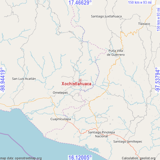
Xochistlahuaca GPS coordinates[2]
16° 47' 39.696" North, 98° 14' 27.816" West
| Map corner | latitude | longitude |
|---|---|---|
| Upper-left | 17.46629°, | -98.94419° |
| Center: | 16.79436°, | -98.24106° |
| Lower-right: | 16.12005°, | -97.53794° |
| Map W x H: | 149.7×149.7 km | = 93×93mi |
| max Lat: | 32.7° ⇑91.8% North |
| Xochistlahuaca: | 16.79436° |
| min Lat: | ⇓8.2% South 14.53588° |
| min Long | Xochistlahuaca | max Long |
| -117.105° | -98.24106° | -86.73105° |
| W 60.6%⇐ | ⇒39.4% E |
Elevation
Elevation of Xochistlahuaca is 375 m = 1230 ft, and this is 878.7 m = 2883 ft below average elevation for this country.
| Max E: |
3497 m = 11473 ft | 70.9% |
| Avg. | 1253.7 m = 4113 ft | |
| Xochistlahuaca | 375 m = 1230 ft | |
Min E: |
-1 m = -3 ft | 29.1% |
See also: Mexico elevation on elevation.city.
Geographical zone
Xochistlahuaca is located in North Torrid zone (between Equator and Tropic of Cancer). Distance of this Northern Tropic circle is 738.6 km =458.9 mi to North.| Distance of | km | miles | from Xochistlahuaca |
|---|---|---|---|
| North Pole | 8139.7 | 5057.8 | to North |
| Arctic Circle | 5533.8 | 3438.5 | to North |
| Tropic Cancer | 738.6 | 458.9 | to North |
| Equator | 1867.4 | 1160.3 | to South |


Nearby cities:
15 places around Xochistlahuaca: (largest is in red/bold)
• Arroyo Gente
8.5 km =5.3 mi,  147°
147°
• Colonia Renacimiento
7.2 km =4.5 mi,  119°
119°
• Cruz Verde II
12.1 km =7.5 mi,  207°
207°
• Cumbre de Barranca Honda
12.3 km =7.6 mi,  235°
235°
• El Santiago
5.4 km =3.4 mi,  135°
135°
• Guadalupe Mano de León
13.1 km =8.1 mi,  34°
34°
• Guadalupe Victoria
7.6 km =4.7 mi, 123°
• La Concepción
15 km =9.3 mi,  187°
187°
• La Guadalupe
11.9 km =7.4 mi, 190°
• Los Liros
6.6 km =4.1 mi,  157°
157°
• Plan de Pierna
4.8 km =3 mi, 117°
• Plan de los Muertos
4.4 km =2.7 mi,  171°
171°
• San Jerónimo
15.8 km =9.8 mi,  305°
305°
• Tlacoachistlahuaca
6.6 km =4.1 mi,  285°
285°
• Zacoalpan
7.4 km =4.6 mi,  222°
222°
Sources, notices
• [Note1] Compared only with cities in Mexico existing in our database
• [Src1] Map data: © OpenStreetMap contributors (CC-BY-SA)
• [Src2] Other city data from geonames.org with taken over terms of usage.
• [Src3] Geographical zone / Annual Mean Temperature by Robert A. Rohde @ Wikipedia
