San Angel geodata
San Angel (Quintana Roo) is a populated place; located in Mexico in America/Cancun (GMT-5) time zone. With population of 1,041 people, there are 8377 cities with bigger population in this country. Compared to other cities in Mexico, 79.5% of cities are located further ↓South; 99.9% of cities are located further ←West and 97% of cities have higher elevation than San Angel. Note1


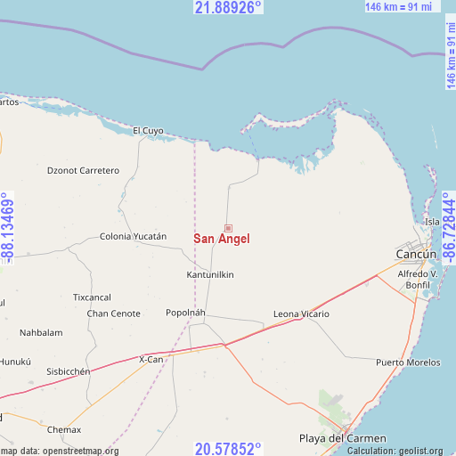
San Angel GPS coordinates[2]
21° 14' 7.26" North, 87° 25' 53.616" West
| Map corner | latitude | longitude |
|---|---|---|
| Upper-left | 21.88926°, | -88.13469° |
| Center: | 21.23535°, | -87.43156° |
| Lower-right: | 20.57852°, | -86.72844° |
| Map W x H: | 145.7×145.7 km | = 90.5×90.5mi |
| max Lat: | 32.7° ⇑20.5% North |
| San Angel: | 21.23535° |
| min Lat: | ⇓79.5% South 14.53588° |
| min Long | San Angel | max Long |
| -117.105° | -87.43156° | -86.73105° |
| W 99.9%⇐ | ⇒0.099999999999994% E |
Elevation
Elevation of San Angel is 10 m = 33 ft, and this is 1243.7 m = 4080 ft below average elevation for this country.
| Max E: |
3497 m = 11473 ft | 97% |
| Avg. | 1253.7 m = 4113 ft | |
| San Angel | 10 m = 33 ft | |
Min E: |
-1 m = -3 ft | 3% |
See also: Mexico elevation on elevation.city.
Geographical zone
San Angel is located in North Torrid zone (between Equator and Tropic of Cancer). Distance of this Northern Tropic circle is 244.8 km =152.1 mi to North.| Distance of | km | miles | from San Angel |
|---|---|---|---|
| North Pole | 7645.9 | 4750.9 | to North |
| Arctic Circle | 5040 | 3131.7 | to North |
| Tropic Cancer | 244.8 | 152.1 | to North |
| Equator | 2361.1 | 1467.1 | to South |


Nearby cities:
15 places around San Angel: (largest is in red/bold)
• Chan Cenote
45.7 km =28.4 mi,  233°
233°
• Chiquilá
24.1 km =15 mi,  24°
24°
• Colonia Yucatán
30.4 km =18.9 mi,  265°
265°
• El Cedral
33.9 km =21.1 mi,  201°
201°
• El Cuyo
40.3 km =25 mi,  320°
320°
• El Ideal
41.1 km =25.5 mi, 196°
• El Tintal
38.4 km =23.9 mi,  185°
185°
• Ignacio Zaragoza
40.5 km =25.2 mi, 193°
• Isla Holbox
32.6 km =20.3 mi,  9°
9°
• Kantunilkín
15.9 km =9.9 mi, 200°
• Leona Vicario
36.2 km =22.5 mi,  138°
138°
• Nuevo Xcán
44.4 km =27.6 mi, 203°
• Popolnah
30.1 km =18.7 mi,  206°
206°
• Solferino
13 km =8.1 mi,  1°
1°
• Vicente Guerrero
28.7 km =17.8 mi, 192°
Sources, notices
• [Note1] Compared only with cities in Mexico existing in our database
• [Src1] Map data: © OpenStreetMap contributors (CC-BY-SA)
• [Src2] Other city data from geonames.org with taken over terms of usage.
• [Src3] Geographical zone / Annual Mean Temperature by Robert A. Rohde @ Wikipedia
