Nahalal geodata
Nahalal (Campeche) is a populated place; located in Mexico in America/Merida (GMT-6) time zone. With population of 522 people, there are 16162 cities with bigger population in this country. Compared to other cities in Mexico, 59.3% of cities are located further ↓South; 97.6% of cities are located further ←West and 82.7% of cities have higher elevation than Nahalal. Note1


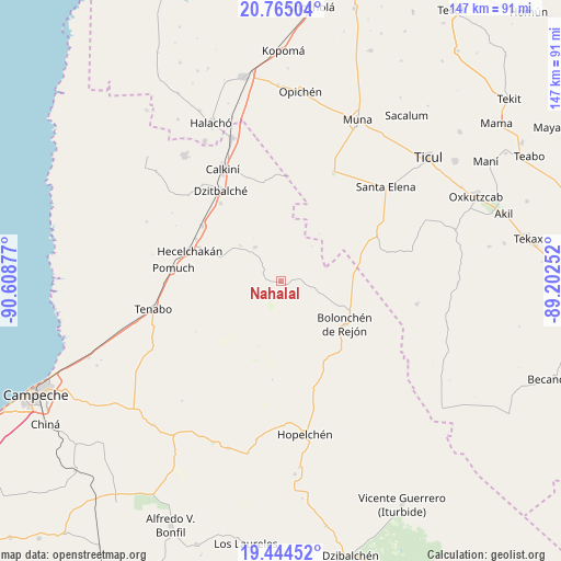
Nahalal GPS coordinates[2]
20° 6' 22.212" North, 89° 54' 20.304" West
| Map corner | latitude | longitude |
|---|---|---|
| Upper-left | 20.76504°, | -90.60877° |
| Center: | 20.10617°, | -89.90564° |
| Lower-right: | 19.44452°, | -89.20252° |
| Map W x H: | 146.8×146.8 km | = 91.2×91.2mi |
| max Lat: | 32.7° ⇑40.7% North |
| Nahalal: | 20.10617° |
| min Lat: | ⇓59.3% South 14.53588° |
| min Long | Nahalal | max Long |
| -117.105° | -89.90564° | -86.73105° |
| W 97.6%⇐ | ⇒2.4% E |
Elevation
Elevation of Nahalal is 63 m = 207 ft, and this is 1190.7 m = 3906 ft below average elevation for this country.
| Max E: |
3497 m = 11473 ft | 82.7% |
| Avg. | 1253.7 m = 4113 ft | |
| Nahalal | 63 m = 207 ft | |
Min E: |
-1 m = -3 ft | 17.3% |
See also: Mexico elevation on elevation.city.
Geographical zone
Nahalal is located in North Torrid zone (between Equator and Tropic of Cancer). Distance of this Northern Tropic circle is 370.3 km =230.1 mi to North.| Distance of | km | miles | from Nahalal |
|---|---|---|---|
| North Pole | 7771.5 | 4829 | to North |
| Arctic Circle | 5165.6 | 3209.8 | to North |
| Tropic Cancer | 370.3 | 230.1 | to North |
| Equator | 2235.6 | 1389.1 | to South |


Nearby cities:
15 places around Nahalal: (largest is in red/bold)
• Bacabchén
25.7 km =16 mi,  322°
322°
• Bolonchén de Rejón
20.1 km =12.5 mi,  124°
124°
• Calkiní
32.9 km =20.4 mi,  332°
332°
• Cumpich
11.2 km =7 mi, 322°
• Dzitbalché
28.4 km =17.6 mi, 326°
• Dzitnup
22.8 km =14.2 mi,  292°
292°
• Hecelchakán
25.1 km =15.6 mi, 288°
• Pocboc
25 km =15.5 mi,  305°
305°
• Pomuch
28.3 km =17.6 mi,  277°
277°
• San Antonio Sahcabchén
32.9 km =20.4 mi, 312°
• Santa Cruz
24.6 km =15.3 mi,  296°
296°
• Santa Cruz Pueblo
32.6 km =20.3 mi, 320°
• Tenabo
34.2 km =21.3 mi,  257°
257°
• Tepakán
35.3 km =21.9 mi,  336°
336°
• Yaxhachen
36 km =22.4 mi,  99°
99°
Sources, notices
• [Note1] Compared only with cities in Mexico existing in our database
• [Src1] Map data: © OpenStreetMap contributors (CC-BY-SA)
• [Src2] Other city data from geonames.org with taken over terms of usage.
• [Src3] Geographical zone / Annual Mean Temperature by Robert A. Rohde @ Wikipedia
