Bolonchén de Rejón geodata
Bolonchén de Rejón (Campeche) is a populated place; located in Mexico in America/Merida (GMT-6) time zone. With population of 3,975 people, there are 2291 cities with bigger population in this country. Compared to other cities in Mexico, 57% of cities are located further ↓South; 97.7% of cities are located further ←West and 78% of cities have higher elevation than Bolonchén de Rejón. Note1


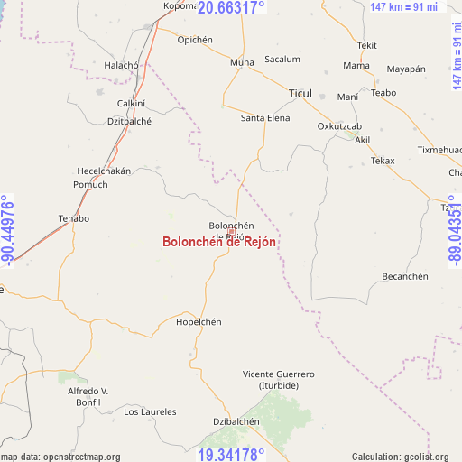
Bolonchén de Rejón GPS coordinates[2]
20° 0' 13.896" North, 89° 44' 47.868" West
| Map corner | latitude | longitude |
|---|---|---|
| Upper-left | 20.66317°, | -90.44976° |
| Center: | 20.00386°, | -89.74663° |
| Lower-right: | 19.34178°, | -89.04351° |
| Map W x H: | 146.9×146.9 km | = 91.3×91.3mi |
| max Lat: | 32.7° ⇑43% North |
| Bolonchén de Rejón: | 20.00386° |
| min Lat: | ⇓57% South 14.53588° |
| min Long | Bolonchén de R | max Long |
| -117.105° | -89.74663° | -86.73105° |
| W 97.7%⇐ | ⇒2.3% E |
Elevation
Elevation of Bolonchén de Rejón is 131 m = 430 ft, and this is 1122.7 m = 3683 ft below average elevation for this country.
| Max E: |
3497 m = 11473 ft | 78% |
| Avg. | 1253.7 m = 4113 ft | |
| Bolonchén de Rejón | 131 m = 430 ft | |
Min E: |
-1 m = -3 ft | 22% |
See also: Mexico elevation on elevation.city.
Geographical zone
Bolonchén de Rejón is located in North Torrid zone (between Equator and Tropic of Cancer). Distance of this Northern Tropic circle is 381.7 km =237.2 mi to North.| Distance of | km | miles | from Bolonchén de Rejón |
|---|---|---|---|
| North Pole | 7782.8 | 4836 | to North |
| Arctic Circle | 5177 | 3216.8 | to North |
| Tropic Cancer | 381.7 | 237.2 | to North |
| Equator | 2224.2 | 1382.1 | to South |


Nearby cities:
15 places around Bolonchén de Rejón: (largest is in red/bold)
• Crucero San Luis
42.4 km =26.3 mi,  216°
216°
• Cumpich
31 km =19.3 mi,  310°
310°
• Dzitnup
42.7 km =26.5 mi,  298°
298°
• Emiliano Zapata
38.2 km =23.7 mi,  49°
49°
• Hopelchén
30.4 km =18.9 mi,  199°
199°
• Ich-Ek
37.9 km =23.5 mi, 217°
• Nahalal
20.1 km =12.5 mi, 304°
• Santa Cruz
44.6 km =27.7 mi, 299°
• Santa Elena
37.7 km =23.4 mi,  16°
16°
• Santa Rita
41.4 km =25.7 mi, 198°
• Suc-Tuc
44.4 km =27.6 mi, 223°
• Xcupil
39.4 km =24.5 mi, 197°
• Xohuayan
43.1 km =26.8 mi,  61°
61°
• Xul
31.6 km =19.6 mi,  69°
69°
• Yaxhachen
19.6 km =12.2 mi, 74°
Sources, notices
• [Note1] Compared only with cities in Mexico existing in our database
• [Src1] Map data: © OpenStreetMap contributors (CC-BY-SA)
• [Src2] Other city data from geonames.org with taken over terms of usage.
• [Src3] Geographical zone / Annual Mean Temperature by Robert A. Rohde @ Wikipedia
