Leona Vicario geodata
Leona Vicario (Quintana Roo) is a populated place; located in Mexico in America/Cancun (GMT-5) time zone. With population of 5,731 people, there are 1623 cities with bigger population in this country. Compared to other cities in Mexico, 76.3% of cities are located further ↓South; 100% of cities are located further ←West and 96.3% of cities have higher elevation than Leona Vicario. Note1


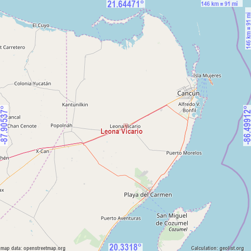
Leona Vicario GPS coordinates[2]
20° 59' 22.92" North, 87° 12' 8.064" West
| Map corner | latitude | longitude |
|---|---|---|
| Upper-left | 21.64471°, | -87.90537° |
| Center: | 20.9897°, | -87.20224° |
| Lower-right: | 20.3318°, | -86.49912° |
| Map W x H: | 146×146 km | = 90.7×90.7mi |
| max Lat: | 32.7° ⇑23.7% North |
| Leona Vicario: | 20.9897° |
| min Lat: | ⇓76.3% South 14.53588° |
| min Long | Leona Vicario | max Long |
| -117.105° | -87.20224° | -86.73105° |
| W 100%⇐ | ⇒0% E |
Elevation
Elevation of Leona Vicario is 11 m = 36 ft, and this is 1242.7 m = 4077 ft below average elevation for this country.
| Max E: |
3497 m = 11473 ft | 96.3% |
| Avg. | 1253.7 m = 4113 ft | |
| Leona Vicario | 11 m = 36 ft | |
Min E: |
-1 m = -3 ft | 3.7% |
See also: Mexico elevation on elevation.city.
Geographical zone
Leona Vicario is located in North Torrid zone (between Equator and Tropic of Cancer). Distance of this Northern Tropic circle is 272.1 km =169.1 mi to North.| Distance of | km | miles | from Leona Vicario |
|---|---|---|---|
| North Pole | 7673.2 | 4767.9 | to North |
| Arctic Circle | 5067.3 | 3148.7 | to North |
| Tropic Cancer | 272.1 | 169.1 | to North |
| Equator | 2333.8 | 1450.2 | to South |


Nearby cities:
15 places around Leona Vicario: (largest is in red/bold)
• Alfredo V. Bonfil
38.4 km =23.9 mi,  73°
73°
• Cancún
42.2 km =26.2 mi,  60°
60°
• El Cedral
36.4 km =22.6 mi,  263°
263°
• El Ideal
37.5 km =23.3 mi,  251°
251°
• El Porvenir
23.1 km =14.4 mi, 64°
• El Tintal
29.5 km =18.3 mi, 248°
• Ignacio Zaragoza
35.6 km =22.1 mi, 250°
• Kantunilkín
32 km =19.9 mi,  292°
292°
• Nuevo Xcán
43.7 km =27.2 mi, 252°
• Playa del Carmen
42.2 km =26.2 mi,  162°
162°
• Popolnah
37.4 km =23.2 mi,  270°
270°
• San Angel
36.2 km =22.5 mi,  318°
318°
• San Francisco
36.5 km =22.7 mi,  239°
239°
• Vicente Guerrero
30.1 km =18.7 mi, 268°
• Zona Urbana Ejido Isla Mujeres
44.6 km =27.7 mi,  54°
54°
Sources, notices
• [Note1] Compared only with cities in Mexico existing in our database
• [Src1] Map data: © OpenStreetMap contributors (CC-BY-SA)
• [Src2] Other city data from geonames.org with taken over terms of usage.
• [Src3] Geographical zone / Annual Mean Temperature by Robert A. Rohde @ Wikipedia
