Ichmul geodata
Ichmul (Yucatán) is a populated place; located in Mexico in America/Merida (GMT-6) time zone. With population of 911 people, there are 9575 cities with bigger population in this country. Compared to other cities in Mexico, 60.5% of cities are located further ↓South; 99.1% of cities are located further ←West and 87% of cities have higher elevation than Ichmul. Note1


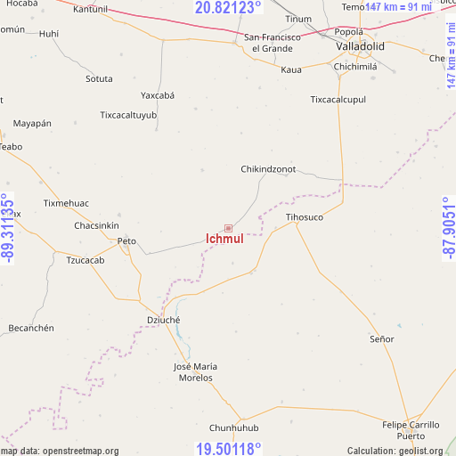
Ichmul GPS coordinates[2]
20° 9' 45.36" North, 88° 36' 29.592" West
| Map corner | latitude | longitude |
|---|---|---|
| Upper-left | 20.82123°, | -89.31135° |
| Center: | 20.1626°, | -88.60822° |
| Lower-right: | 19.50118°, | -87.9051° |
| Map W x H: | 146.8×146.8 km | = 91.2×91.2mi |
| max Lat: | 32.7° ⇑39.5% North |
| Ichmul: | 20.1626° |
| min Lat: | ⇓60.5% South 14.53588° |
| min Long | Ichmul | max Long |
| -117.105° | -88.60822° | -86.73105° |
| W 99.1%⇐ | ⇒0.90000000000001% E |
Elevation
Elevation of Ichmul is 34 m = 112 ft, and this is 1219.7 m = 4002 ft below average elevation for this country.
| Max E: |
3497 m = 11473 ft | 87% |
| Avg. | 1253.7 m = 4113 ft | |
| Ichmul | 34 m = 112 ft | |
Min E: |
-1 m = -3 ft | 13% |
See also: Mexico elevation on elevation.city.
Geographical zone
Ichmul is located in North Torrid zone (between Equator and Tropic of Cancer). Distance of this Northern Tropic circle is 364 km =226.2 mi to North.| Distance of | km | miles | from Ichmul |
|---|---|---|---|
| North Pole | 7765.2 | 4825.1 | to North |
| Arctic Circle | 5159.3 | 3205.8 | to North |
| Tropic Cancer | 364 | 226.2 | to North |
| Equator | 2241.9 | 1393.1 | to South |


Nearby cities:
15 places around Ichmul: (largest is in red/bold)
• Bulukax
28 km =17.4 mi,  217°
217°
• Chikindzonot
22.9 km =14.2 mi,  33°
33°
• Dziuche
36.2 km =22.5 mi, 215°
• Ekpedz
25.2 km =15.7 mi,  47°
47°
• Huay Max
16 km =9.9 mi,  147°
147°
• La Esperanza
33.3 km =20.7 mi,  175°
175°
• Peto
33.1 km =20.6 mi,  263°
263°
• Saban
16 km =9.9 mi, 153°
• San Diego
37.5 km =23.3 mi,  199°
199°
• Tahdziu
35.5 km =22.1 mi,  277°
277°
• Tiholop
20.7 km =12.9 mi,  335°
335°
• Tihosuco
24.8 km =15.4 mi,  81°
81°
• X Cabil
15.1 km =9.4 mi,  88°
88°
• Xcalak Dzonot
31.1 km =19.3 mi,  7°
7°
• Zacalaca
11.2 km =7 mi,  173°
173°
Sources, notices
• [Note1] Compared only with cities in Mexico existing in our database
• [Src1] Map data: © OpenStreetMap contributors (CC-BY-SA)
• [Src2] Other city data from geonames.org with taken over terms of usage.
• [Src3] Geographical zone / Annual Mean Temperature by Robert A. Rohde @ Wikipedia
