Cuauhtémoc geodata
Cuauhtémoc (Veracruz) is a populated place; located in Mexico in America/Mexico_City (GMT-6) time zone. With population of 725 people, there are 12042 cities with bigger population in this country. Compared to other cities in Mexico, 54.2% of cities are located further ↑North; 75.2% of cities are located further ←West and 51.2% of cities have higher elevation than Cuauhtémoc. Note1


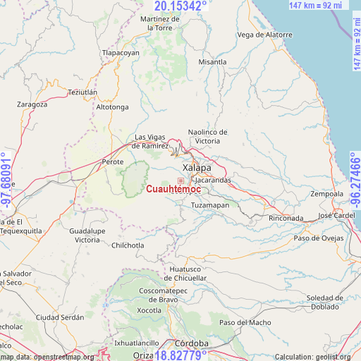
Cuauhtémoc GPS coordinates[2]
19° 29' 31.056" North, 96° 58' 40.008" West
| Map corner | latitude | longitude |
|---|---|---|
| Upper-left | 20.15342°, | -97.68091° |
| Center: | 19.49196°, | -96.97778° |
| Lower-right: | 18.82779°, | -96.27466° |
| Map W x H: | 147.4×147.4 km | = 91.6×91.6mi |
| max Lat: | 32.7° ⇑54.2% North |
| Cuauhtémoc: | 19.49196° |
| min Lat: | ⇓45.8% South 14.53588° |
| min Long | Cuauhtémoc | max Long |
| -117.105° | -96.97778° | -86.73105° |
| W 75.2%⇐ | ⇒24.8% E |
Elevation
Elevation of Cuauhtémoc is 1374 m = 4508 ft, and this is 120.3 m = 395 ft above average elevation for this country.
| Max E: |
3497 m = 11473 ft | 51.2% |
| Cuauhtémoc | 1374 m 4508 ft | |
| Avg. | 1253.7 m = 4113 ft | |
Min E: |
-1 m = -3 ft | 48.8% |
See also: Mexico elevation on elevation.city.
Geographical zone
Cuauhtémoc is located in North Torrid zone (between Equator and Tropic of Cancer). Distance of this Northern Tropic circle is 438.6 km =272.5 mi to North.| Distance of | km | miles | from Cuauhtémoc |
|---|---|---|---|
| North Pole | 7839.8 | 4871.4 | to North |
| Arctic Circle | 5233.9 | 3252.2 | to North |
| Tropic Cancer | 438.6 | 272.5 | to North |
| Equator | 2167.3 | 1346.7 | to South |


Nearby cities:
15 places around Cuauhtémoc: (largest is in red/bold)
• Cañada Larga
5.3 km =3.3 mi,  0°
0°
• Cinco Palos
1.5 km =0.9 mi,  300°
300°
• Coatepec
4.7 km =2.9 mi,  158°
158°
• Colonia Obrera (Las Puentes)
7.2 km =4.5 mi,  168°
168°
• Colonia Úrsulo Galván
7 km =4.3 mi,  180°
180°
• Guadalupe Victoria
7.2 km =4.5 mi,  14°
14°
• La Laguna
4.8 km =3 mi,  103°
103°
• La Orduña
6.3 km =3.9 mi,  135°
135°
• Mariano Escobedo
3.5 km =2.2 mi,  80°
80°
• Naranjillos
6.1 km =3.8 mi, 1°
• Pacho Viejo
6.5 km =4 mi, 99°
• Potrero del Bordo (Santa María)
5.1 km =3.2 mi, 4°
• Rancho Viejo
3.9 km =2.4 mi,  359°
359°
• San Antonio Hidalgo
5.5 km =3.4 mi, 5°
• Zimpizahua
7.2 km =4.5 mi,  154°
154°
Sources, notices
• [Note1] Compared only with cities in Mexico existing in our database
• [Src1] Map data: © OpenStreetMap contributors (CC-BY-SA)
• [Src2] Other city data from geonames.org with taken over terms of usage.
• [Src3] Geographical zone / Annual Mean Temperature by Robert A. Rohde @ Wikipedia
