Buena Vista geodata
Buena Vista (Veracruz) is a populated place; located in Mexico in America/Mexico_City (GMT-6) time zone. With population of 932 people, there are 9352 cities with bigger population in this country. Compared to other cities in Mexico, 56.2% of cities are located further ↑North; 79.4% of cities are located further ←West and 75.9% of cities have higher elevation than Buena Vista. Note1


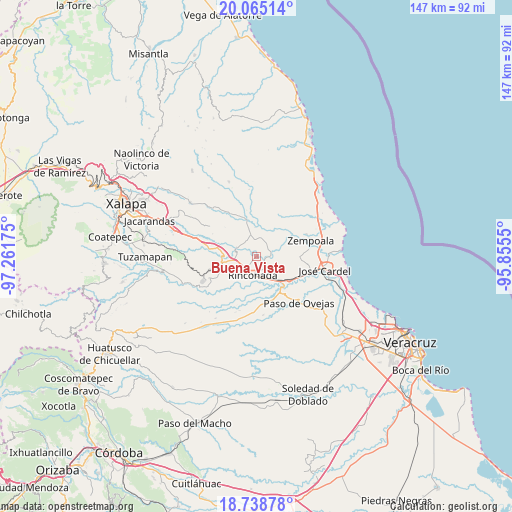
Buena Vista GPS coordinates[2]
19° 24' 11.916" North, 96° 33' 31.032" West
| Map corner | latitude | longitude |
|---|---|---|
| Upper-left | 20.06514°, | -97.26175° |
| Center: | 19.40331°, | -96.55862° |
| Lower-right: | 18.73878°, | -95.8555° |
| Map W x H: | 147.5×147.5 km | = 91.7×91.7mi |
| max Lat: | 32.7° ⇑56.2% North |
| Buena Vista: | 19.40331° |
| min Lat: | ⇓43.8% South 14.53588° |
| min Long | Buena Vista | max Long |
| -117.105° | -96.55862° | -86.73105° |
| W 79.4%⇐ | ⇒20.6% E |
Elevation
Elevation of Buena Vista is 189 m = 620 ft, and this is 1064.7 m = 3493 ft below average elevation for this country.
| Max E: |
3497 m = 11473 ft | 75.9% |
| Avg. | 1253.7 m = 4113 ft | |
| Buena Vista | 189 m = 620 ft | |
Min E: |
-1 m = -3 ft | 24.1% |
See also: Mexico elevation on elevation.city.
Geographical zone
Buena Vista is located in North Torrid zone (between Equator and Tropic of Cancer). Distance of this Northern Tropic circle is 448.5 km =278.7 mi to North.| Distance of | km | miles | from Buena Vista |
|---|---|---|---|
| North Pole | 7849.6 | 4877.5 | to North |
| Arctic Circle | 5243.7 | 3258.3 | to North |
| Tropic Cancer | 448.5 | 278.7 | to North |
| Equator | 2157.4 | 1340.5 | to South |


Nearby cities:
15 places around Buena Vista: (largest is in red/bold)
• Actopan
12.8 km =8 mi,  331°
331°
• Agua Caliente
13 km =8.1 mi,  224°
224°
• Chichicaxtle
11.6 km =7.2 mi,  125°
125°
• El Aguaje
6.3 km =3.9 mi,  284°
284°
• El Crucero
10.4 km =6.5 mi,  158°
158°
• Jareros
10.1 km =6.3 mi,  61°
61°
• La Esperanza
8.4 km =5.2 mi,  358°
358°
• Los Ídolos
4.4 km =2.7 mi,  77°
77°
• Palo Gacho
8.3 km =5.2 mi,  260°
260°
• Paso de la Milpa
6.3 km =3.9 mi,  295°
295°
• Plan del Río
9.8 km =6.1 mi,  269°
269°
• Rinconada
5.5 km =3.4 mi,  187°
187°
• Santa Rosa
12.3 km =7.6 mi,  52°
52°
• Tamarindo
10 km =6.2 mi, 134°
• Villa Emiliano Zapata
11.3 km =7 mi,  246°
246°
Sources, notices
• [Note1] Compared only with cities in Mexico existing in our database
• [Src1] Map data: © OpenStreetMap contributors (CC-BY-SA)
• [Src2] Other city data from geonames.org with taken over terms of usage.
• [Src3] Geographical zone / Annual Mean Temperature by Robert A. Rohde @ Wikipedia
