Tlaltetela geodata
Tlaltetela (Veracruz) is a seat of a second-order administrative division; located in Mexico in America/Mexico_City (GMT-6) time zone. With population of 4,528 people, there are 2032 cities with bigger population in this country. Compared to other cities in Mexico, 58.5% of cities are located further ↑North; 76.1% of cities are located further ←West and 60.4% of cities have higher elevation than Tlaltetela. Note1


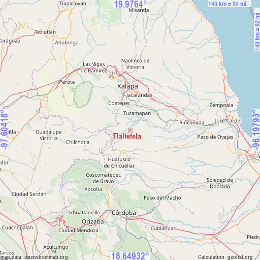
Tlaltetela GPS coordinates[2]
19° 18' 51.156" North, 96° 54' 3.78" West
| Map corner | latitude | longitude |
|---|---|---|
| Upper-left | 19.9764°, | -97.60418° |
| Center: | 19.31421°, | -96.90105° |
| Lower-right: | 18.64932°, | -96.19793° |
| Map W x H: | 147.6×147.6 km | = 91.7×91.7mi |
| max Lat: | 32.7° ⇑58.5% North |
| Tlaltetela: | 19.31421° |
| min Lat: | ⇓41.5% South 14.53588° |
| min Long | Tlaltetela | max Long |
| -117.105° | -96.90105° | -86.73105° |
| W 76.1%⇐ | ⇒23.9% E |
Elevation
Elevation of Tlaltetela is 977 m = 3205 ft, and this is 276.7 m = 908 ft below average elevation for this country.
| Max E: |
3497 m = 11473 ft | 60.4% |
| Avg. | 1253.7 m = 4113 ft | |
| Tlaltetela | 977 m = 3205 ft | |
Min E: |
-1 m = -3 ft | 39.6% |
See also: Mexico elevation on elevation.city.
Geographical zone
Tlaltetela is located in North Torrid zone (between Equator and Tropic of Cancer). Distance of this Northern Tropic circle is 458.4 km =284.8 mi to North.| Distance of | km | miles | from Tlaltetela |
|---|---|---|---|
| North Pole | 7859.5 | 4883.7 | to North |
| Arctic Circle | 5253.6 | 3264.4 | to North |
| Tropic Cancer | 458.4 | 284.8 | to North |
| Equator | 2147.5 | 1334.4 | to South |


Nearby cities:
15 places around Tlaltetela: (largest is in red/bold)
• Colonia San José
8.2 km =5.1 mi,  151°
151°
• Cosautlán
9.6 km =6 mi,  281°
281°
• El Santuario (Barrio Nuevo)
4.5 km =2.8 mi,  174°
174°
• Emiliano Zapata
8.1 km =5 mi,  258°
258°
• Independencia
9.3 km =5.8 mi,  329°
329°
• La Reforma
4.1 km =2.5 mi,  288°
288°
• Limones
3.5 km =2.2 mi,  318°
318°
• Llano Grande
6.6 km =4.1 mi,  19°
19°
• Monte Blanco
7.7 km =4.8 mi,  336°
336°
• Piedra Parada
7.2 km =4.5 mi,  300°
300°
• Pinillo
4.6 km =2.9 mi,  240°
240°
• San Miguel Tlapéxcatl
9.6 km =6 mi, 263°
• Tenampa
7.5 km =4.7 mi, 166°
• Tlapala
6.1 km =3.8 mi,  197°
197°
• Vaquería
5.7 km =3.5 mi,  273°
273°
Sources, notices
• [Note1] Compared only with cities in Mexico existing in our database
• [Src1] Map data: © OpenStreetMap contributors (CC-BY-SA)
• [Src2] Other city data from geonames.org with taken over terms of usage.
• [Src3] Geographical zone / Annual Mean Temperature by Robert A. Rohde @ Wikipedia
