Monte Blanco geodata
Monte Blanco (Veracruz) is a populated place; located in Mexico in America/Mexico_City (GMT-6) time zone. With population of 1,708 people, there are 5088 cities with bigger population in this country. Compared to other cities in Mexico, 56.8% of cities are located further ↑North; 75.8% of cities are located further ←West and 60.1% of cities have higher elevation than Monte Blanco. Note1


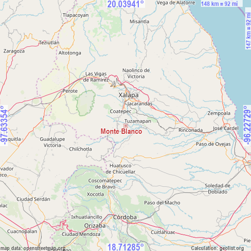
Monte Blanco GPS coordinates[2]
19° 22' 38.928" North, 96° 55' 49.476" West
| Map corner | latitude | longitude |
|---|---|---|
| Upper-left | 20.03941°, | -97.63354° |
| Center: | 19.37748°, | -96.93041° |
| Lower-right: | 18.71285°, | -96.22729° |
| Map W x H: | 147.5×147.5 km | = 91.7×91.7mi |
| max Lat: | 32.7° ⇑56.8% North |
| Monte Blanco: | 19.37748° |
| min Lat: | ⇓43.2% South 14.53588° |
| min Long | Monte Blanco | max Long |
| -117.105° | -96.93041° | -86.73105° |
| W 75.8%⇐ | ⇒24.2% E |
Elevation
Elevation of Monte Blanco is 997 m = 3271 ft, and this is 256.7 m = 842 ft below average elevation for this country.
| Max E: |
3497 m = 11473 ft | 60.1% |
| Avg. | 1253.7 m = 4113 ft | |
| Monte Blanco | 997 m = 3271 ft | |
Min E: |
-1 m = -3 ft | 39.9% |
See also: Mexico elevation on elevation.city.
Geographical zone
Monte Blanco is located in North Torrid zone (between Equator and Tropic of Cancer). Distance of this Northern Tropic circle is 451.3 km =280.4 mi to North.| Distance of | km | miles | from Monte Blanco |
|---|---|---|---|
| North Pole | 7852.5 | 4879.3 | to North |
| Arctic Circle | 5246.6 | 3260.1 | to North |
| Tropic Cancer | 451.3 | 280.4 | to North |
| Equator | 2154.6 | 1338.8 | to South |


Nearby cities:
15 places around Monte Blanco: (largest is in red/bold)
• Baxtla
5.1 km =3.2 mi,  251°
251°
• Colonia Obrera (Las Puentes)
6.7 km =4.2 mi,  328°
328°
• Colonia Úrsulo Galván
7.6 km =4.7 mi,  318°
318°
• El Grande
6.4 km =4 mi,  13°
13°
• Independencia
2 km =1.2 mi,  299°
299°
• La Reforma
5.8 km =3.6 mi,  187°
187°
• Limones
4.4 km =2.7 mi,  170°
170°
• Llano Grande
5.3 km =3.3 mi,  98°
98°
• Mahuixtlan
3.8 km =2.4 mi,  20°
20°
• Piedra Parada
4.6 km =2.9 mi,  222°
222°
• San Marcos de León
6.3 km =3.9 mi, 325°
• Teocelo
4.6 km =2.9 mi,  281°
281°
• Tuzamapan
7.5 km =4.7 mi,  68°
68°
• Vaquería
7.2 km =4.5 mi,  201°
201°
• Zimpizahua
6.5 km =4 mi,  343°
343°
Sources, notices
• [Note1] Compared only with cities in Mexico existing in our database
• [Src1] Map data: © OpenStreetMap contributors (CC-BY-SA)
• [Src2] Other city data from geonames.org with taken over terms of usage.
• [Src3] Geographical zone / Annual Mean Temperature by Robert A. Rohde @ Wikipedia
