Cosautlán geodata
Cosautlán (Veracruz) is a seat of a second-order administrative division; located in Mexico in America/Mexico_City (GMT-6) time zone. With population of 4,617 people, there are 1992 cities with bigger population in this country. Compared to other cities in Mexico, 58% of cities are located further ↑North; 75% of cities are located further ←West and 53.7% of cities have higher elevation than Cosautlán. Note1


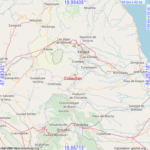
Cosautlán GPS coordinates[2]
19° 19' 55.056" North, 96° 59' 25.08" West
| Map corner | latitude | longitude |
|---|---|---|
| Upper-left | 19.99408°, | -97.69343° |
| Center: | 19.33196°, | -96.9903° |
| Lower-right: | 18.66715°, | -96.28718° |
| Map W x H: | 147.5×147.5 km | = 91.7×91.7mi |
| max Lat: | 32.7° ⇑58% North |
| Cosautlán: | 19.33196° |
| min Lat: | ⇓42% South 14.53588° |
| min Long | Cosautlán | max Long |
| -117.105° | -96.9903° | -86.73105° |
| W 75%⇐ | ⇒25% E |
Elevation
Elevation of Cosautlán is 1257 m = 4124 ft, and this is 3.3 m = 11 ft above average elevation for this country.
| Max E: |
3497 m = 11473 ft | 53.7% |
| Cosautlán | 1257 m 4124 ft | |
| Avg. | 1253.7 m = 4113 ft | |
Min E: |
-1 m = -3 ft | 46.3% |
See also: Mexico elevation on elevation.city.
Geographical zone
Cosautlán is located in North Torrid zone (between Equator and Tropic of Cancer). Distance of this Northern Tropic circle is 456.4 km =283.6 mi to North.| Distance of | km | miles | from Cosautlán |
|---|---|---|---|
| North Pole | 7857.5 | 4882.4 | to North |
| Arctic Circle | 5251.7 | 3263.3 | to North |
| Tropic Cancer | 456.4 | 283.6 | to North |
| Equator | 2149.5 | 1335.6 | to South |


Nearby cities:
15 places around Cosautlán: (largest is in red/bold)
• Barranca Nueva
5.1 km =3.2 mi,  276°
276°
• Baxtla
3.7 km =2.3 mi,  23°
23°
• Casa Quemada
2.7 km =1.7 mi,  268°
268°
• Cetlalpan
5.8 km =3.6 mi,  304°
304°
• Emiliano Zapata
3.9 km =2.4 mi,  158°
158°
• Huehuetecpan
1.7 km =1.1 mi,  219°
219°
• La Reforma
5.5 km =3.4 mi,  97°
97°
• Limones
7.1 km =4.4 mi,  84°
84°
• Piedra Parada
3.6 km =2.2 mi,  62°
62°
• Pinillo
6.9 km =4.3 mi,  128°
128°
• San Martín Comalapa
6.8 km =4.2 mi,  188°
188°
• San Miguel Tlapéxcatl
3.1 km =1.9 mi,  182°
182°
• Teocelo
6.2 km =3.9 mi, 16°
• Texin
4.1 km =2.5 mi,  337°
337°
• Vaquería
4 km =2.5 mi,  114°
114°
Sources, notices
• [Note1] Compared only with cities in Mexico existing in our database
• [Src1] Map data: © OpenStreetMap contributors (CC-BY-SA)
• [Src2] Other city data from geonames.org with taken over terms of usage.
• [Src3] Geographical zone / Annual Mean Temperature by Robert A. Rohde @ Wikipedia
