La Capilla geodata
La Capilla (Veracruz) is a populated place; located in Mexico in America/Mexico_City (GMT-6) time zone. With population of 1,446 people, there are 5968 cities with bigger population in this country. Compared to other cities in Mexico, 67.1% of cities are located further ↑North; 81.1% of cities are located further ←West and 88% of cities have higher elevation than La Capilla. Note1


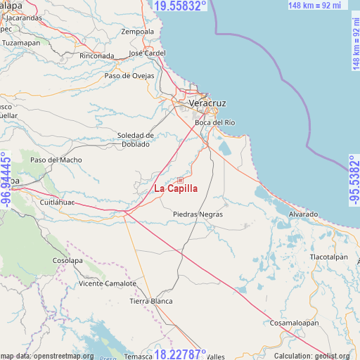
La Capilla GPS coordinates[2]
18° 53' 39.912" North, 96° 14' 28.752" West
| Map corner | latitude | longitude |
|---|---|---|
| Upper-left | 19.55832°, | -96.94445° |
| Center: | 18.89442°, | -96.24132° |
| Lower-right: | 18.22787°, | -95.5382° |
| Map W x H: | 147.9×147.9 km | = 91.9×91.9mi |
| max Lat: | 32.7° ⇑67.1% North |
| La Capilla: | 18.89442° |
| min Lat: | ⇓32.9% South 14.53588° |
| min Long | La Capilla | max Long |
| -117.105° | -96.24132° | -86.73105° |
| W 81.1%⇐ | ⇒18.9% E |
Elevation
Elevation of La Capilla is 30 m = 98 ft, and this is 1223.7 m = 4015 ft below average elevation for this country.
| Max E: |
3497 m = 11473 ft | 88% |
| Avg. | 1253.7 m = 4113 ft | |
| La Capilla | 30 m = 98 ft | |
Min E: |
-1 m = -3 ft | 12% |
See also: Mexico elevation on elevation.city.
Geographical zone
La Capilla is located in North Torrid zone (between Equator and Tropic of Cancer). Distance of this Northern Tropic circle is 505.1 km =313.9 mi to North.| Distance of | km | miles | from La Capilla |
|---|---|---|---|
| North Pole | 7906.2 | 4912.7 | to North |
| Arctic Circle | 5300.3 | 3293.5 | to North |
| Tropic Cancer | 505.1 | 313.9 | to North |
| Equator | 2100.9 | 1305.4 | to South |


Nearby cities:
15 places around La Capilla: (largest is in red/bold)
• Cotaxtla
17.6 km =10.9 mi,  248°
248°
• Cuyucuenda
13 km =8.1 mi,  195°
195°
• Ejidal
1.9 km =1.2 mi,  57°
57°
• El Zacatal
7.7 km =4.8 mi,  322°
322°
• Jamapa
16.4 km =10.2 mi,  359°
359°
• Juan de Alfaro
15.9 km =9.9 mi,  33°
33°
• La Javilla
16.8 km =10.4 mi,  353°
353°
• Las Puertas
16.9 km =10.5 mi,  12°
12°
• Los Robles
15.7 km =9.8 mi, 56°
• Mata Cabestro (La Víbora)
18.2 km =11.3 mi,  83°
83°
• Mata Tejón
16.3 km =10.1 mi,  272°
272°
• Mata de Lázaro
14.4 km =8.9 mi,  176°
176°
• Mozambique
18.4 km =11.4 mi, 355°
• Paloma Sola
18.3 km =11.4 mi,  100°
100°
• Piedras Negras
15.6 km =9.7 mi,  152°
152°
Sources, notices
• [Note1] Compared only with cities in Mexico existing in our database
• [Src1] Map data: © OpenStreetMap contributors (CC-BY-SA)
• [Src2] Other city data from geonames.org with taken over terms of usage.
• [Src3] Geographical zone / Annual Mean Temperature by Robert A. Rohde @ Wikipedia
