Ejidal geodata
Ejidal (Veracruz) is a populated place; located in Mexico in America/Mexico_City (GMT-6) time zone. With population of 1,111 people, there are 7820 cities with bigger population in this country. Compared to other cities in Mexico, 66.9% of cities are located further ↑North; 81.2% of cities are located further ←West and 90% of cities have higher elevation than Ejidal. Note1


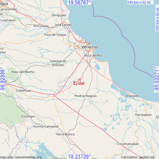
Ejidal GPS coordinates[2]
18° 54' 13.68" North, 96° 13' 32.988" West
| Map corner | latitude | longitude |
|---|---|---|
| Upper-left | 19.56767°, | -96.92896° |
| Center: | 18.9038°, | -96.22583° |
| Lower-right: | 18.23729°, | -95.52271° |
| Map W x H: | 147.9×147.9 km | = 91.9×91.9mi |
| max Lat: | 32.7° ⇑66.9% North |
| Ejidal: | 18.9038° |
| min Lat: | ⇓33.1% South 14.53588° |
| min Long | Ejidal | max Long |
| -117.105° | -96.22583° | -86.73105° |
| W 81.2%⇐ | ⇒18.8% E |
Elevation
Elevation of Ejidal is 24 m = 79 ft, and this is 1229.7 m = 4034 ft below average elevation for this country.
| Max E: |
3497 m = 11473 ft | 90% |
| Avg. | 1253.7 m = 4113 ft | |
| Ejidal | 24 m = 79 ft | |
Min E: |
-1 m = -3 ft | 10% |
See also: Mexico elevation on elevation.city.
Geographical zone
Ejidal is located in North Torrid zone (between Equator and Tropic of Cancer). Distance of this Northern Tropic circle is 504 km =313.2 mi to North.| Distance of | km | miles | from Ejidal |
|---|---|---|---|
| North Pole | 7905.2 | 4912.1 | to North |
| Arctic Circle | 5299.3 | 3292.8 | to North |
| Tropic Cancer | 504 | 313.2 | to North |
| Equator | 2101.9 | 1306.1 | to South |


Nearby cities:
15 places around Ejidal: (largest is in red/bold)
• Cuyucuenda
14.5 km =9 mi,  200°
200°
• El Zacatal
8.1 km =5 mi,  308°
308°
• Jamapa
15.4 km =9.6 mi,  353°
353°
• Juan de Alfaro
14.2 km =8.8 mi,  30°
30°
• La Capilla
1.9 km =1.2 mi,  237°
237°
• La Gloria
16.7 km =10.4 mi,  40°
40°
• La Javilla
16.1 km =10 mi, 346°
• Las Puertas
15.5 km =9.6 mi,  7°
7°
• Los Robles
13.7 km =8.5 mi,  55°
55°
• Mata Cabestro (La Víbora)
16.5 km =10.3 mi,  85°
85°
• Mata de Lázaro
15.4 km =9.6 mi,  182°
182°
• Mozambique
17.6 km =10.9 mi, 350°
• Paloma Sola
17 km =10.6 mi,  104°
104°
• Paso del Toro
17.4 km =10.8 mi, 33°
• Piedras Negras
15.9 km =9.9 mi,  159°
159°
Sources, notices
• [Note1] Compared only with cities in Mexico existing in our database
• [Src1] Map data: © OpenStreetMap contributors (CC-BY-SA)
• [Src2] Other city data from geonames.org with taken over terms of usage.
• [Src3] Geographical zone / Annual Mean Temperature by Robert A. Rohde @ Wikipedia
