San Miguel geodata
San Miguel (Veracruz) is a populated place; located in Mexico in America/Mexico_City (GMT-6) time zone. With population of 692 people, there are 12576 cities with bigger population in this country. Compared to other cities in Mexico, 77.9% of cities are located further ↑North; 84.7% of cities are located further ←West and 77.4% of cities have higher elevation than San Miguel. Note1


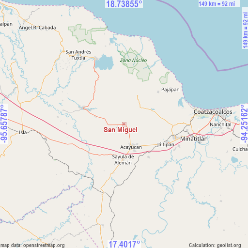
San Miguel GPS coordinates[2]
18° 4' 17.04" North, 94° 57' 17.064" West
| Map corner | latitude | longitude |
|---|---|---|
| Upper-left | 18.73855°, | -95.65787° |
| Center: | 18.0714°, | -94.95474° |
| Lower-right: | 17.4017°, | -94.25162° |
| Map W x H: | 148.6×148.6 km | = 92.3×92.3mi |
| max Lat: | 32.7° ⇑77.9% North |
| San Miguel: | 18.0714° |
| min Lat: | ⇓22.1% South 14.53588° |
| min Long | San Miguel | max Long |
| -117.105° | -94.95474° | -86.73105° |
| W 84.7%⇐ | ⇒15.3% E |
Elevation
Elevation of San Miguel is 143 m = 469 ft, and this is 1110.7 m = 3644 ft below average elevation for this country.
| Max E: |
3497 m = 11473 ft | 77.4% |
| Avg. | 1253.7 m = 4113 ft | |
| San Miguel | 143 m = 469 ft | |
Min E: |
-1 m = -3 ft | 22.6% |
See also: Mexico elevation on elevation.city.
Geographical zone
San Miguel is located in North Torrid zone (between Equator and Tropic of Cancer). Distance of this Northern Tropic circle is 596.6 km =370.7 mi to North.| Distance of | km | miles | from San Miguel |
|---|---|---|---|
| North Pole | 7997.7 | 4969.5 | to North |
| Arctic Circle | 5391.8 | 3350.3 | to North |
| Tropic Cancer | 596.6 | 370.7 | to North |
| Equator | 2009.4 | 1248.6 | to South |


Nearby cities:
15 places around San Miguel: (largest is in red/bold)
• Campo de Águila
3.3 km =2.1 mi,  262°
262°
• Cirilo Vázquez Lagunes
10.1 km =6.3 mi,  157°
157°
• Colonia Hermosa
11.6 km =7.2 mi,  301°
301°
• Comején
7.4 km =4.6 mi,  98°
98°
• Cuilonia Nuevo
10.2 km =6.3 mi,  24°
24°
• El Hato
8.4 km =5.2 mi,  184°
184°
• Ixhuapan
10.5 km =6.5 mi,  128°
128°
• Ixtagapa
2.3 km =1.4 mi,  137°
137°
• La Estribera
8.6 km =5.3 mi,  54°
54°
• Las Palomas (Bajo Paloma)
10.1 km =6.3 mi,  34°
34°
• Monte Grande
7.1 km =4.4 mi,  110°
110°
• Pitalillo
4.2 km =2.6 mi,  70°
70°
• Quiamoloapan
4.5 km =2.8 mi, 256°
• San Andrés Chamilpa
10.9 km =6.8 mi,  78°
78°
• Tecuanapa
8.6 km =5.3 mi,  149°
149°
Sources, notices
• [Note1] Compared only with cities in Mexico existing in our database
• [Src1] Map data: © OpenStreetMap contributors (CC-BY-SA)
• [Src2] Other city data from geonames.org with taken over terms of usage.
• [Src3] Geographical zone / Annual Mean Temperature by Robert A. Rohde @ Wikipedia
