El Hato geodata
El Hato (Veracruz) is a populated place; located in Mexico in America/Mexico_City (GMT-6) time zone. With population of 804 people, there are 10860 cities with bigger population in this country. Compared to other cities in Mexico, 78.7% of cities are located further ↑North; 84.7% of cities are located further ←West and 79.2% of cities have higher elevation than El Hato. Note1


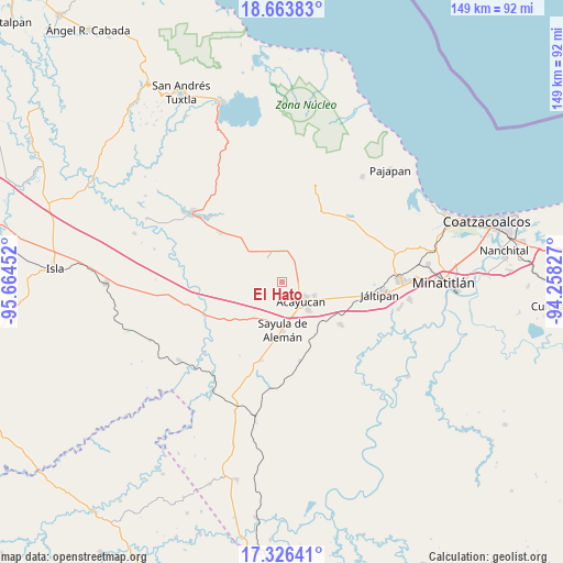
El Hato GPS coordinates[2]
17° 59' 47.004" North, 94° 57' 41.004" West
| Map corner | latitude | longitude |
|---|---|---|
| Upper-left | 18.66383°, | -95.66452° |
| Center: | 17.99639°, | -94.96139° |
| Lower-right: | 17.32641°, | -94.25827° |
| Map W x H: | 148.7×148.7 km | = 92.4×92.4mi |
| max Lat: | 32.7° ⇑78.7% North |
| El Hato: | 17.99639° |
| min Lat: | ⇓21.3% South 14.53588° |
| min Long | El Hato | max Long |
| -117.105° | -94.96139° | -86.73105° |
| W 84.7%⇐ | ⇒15.3% E |
Elevation
Elevation of El Hato is 107 m = 351 ft, and this is 1146.7 m = 3762 ft below average elevation for this country.
| Max E: |
3497 m = 11473 ft | 79.2% |
| Avg. | 1253.7 m = 4113 ft | |
| El Hato | 107 m = 351 ft | |
Min E: |
-1 m = -3 ft | 20.8% |
See also: Mexico elevation on elevation.city.
Geographical zone
El Hato is located in North Torrid zone (between Equator and Tropic of Cancer). Distance of this Northern Tropic circle is 604.9 km =375.9 mi to North.| Distance of | km | miles | from El Hato |
|---|---|---|---|
| North Pole | 8006.1 | 4974.8 | to North |
| Arctic Circle | 5400.2 | 3355.5 | to North |
| Tropic Cancer | 604.9 | 375.9 | to North |
| Equator | 2001 | 1243.4 | to South |


Nearby cities:
15 places around El Hato: (largest is in red/bold)
• Acayucan
7.2 km =4.5 mi,  135°
135°
• Campo de Águila
8.3 km =5.2 mi,  341°
341°
• Cirilo Vázquez Lagunes
4.7 km =2.9 mi,  102°
102°
• Colonia Lealtad
7.2 km =4.5 mi,  120°
120°
• Congregación Hidalgo
6.6 km =4.1 mi,  188°
188°
• Dehesa
7.2 km =4.5 mi,  212°
212°
• Fraccionamiento Santa Cruz
7.5 km =4.7 mi,  111°
111°
• Ixhuapan
9.2 km =5.7 mi,  78°
78°
• Ixtagapa
7 km =4.3 mi,  19°
19°
• Monte Grande
9.4 km =5.8 mi,  51°
51°
• Nuevo Poblado el Hato
6.7 km =4.2 mi, 186°
• Quiamoloapan
8.1 km =5 mi,  333°
333°
• San Miguel
8.4 km =5.2 mi,  4°
4°
• Soconusco
9.3 km =5.8 mi, 113°
• Tecuanapa
5.1 km =3.2 mi, 80°
Sources, notices
• [Note1] Compared only with cities in Mexico existing in our database
• [Src1] Map data: © OpenStreetMap contributors (CC-BY-SA)
• [Src2] Other city data from geonames.org with taken over terms of usage.
• [Src3] Geographical zone / Annual Mean Temperature by Robert A. Rohde @ Wikipedia
