Hipólito Landeros (Zacatal) geodata
Hipólito Landeros (Zacatal) (Veracruz) is a populated place; located in Mexico in America/Mexico_City (GMT-6) time zone. With population of 597 people, there are 14400 cities with bigger population in this country. Compared to other cities in Mexico, 79.1% of cities are located further ↑North; 85% of cities are located further ←West and 84.5% of cities have higher elevation than Hipólito Landeros (Zacatal). Note1
Current local time in Hipólito Landeros (Zacatal):
08:44 AM, MondayDifference from your time zone: hours


Hipólito Landeros (Zacatal) GPS coordinates[2]
17° 57' 37.008" North, 94° 48' 51.984" West
| Map corner | latitude | longitude |
|---|---|---|
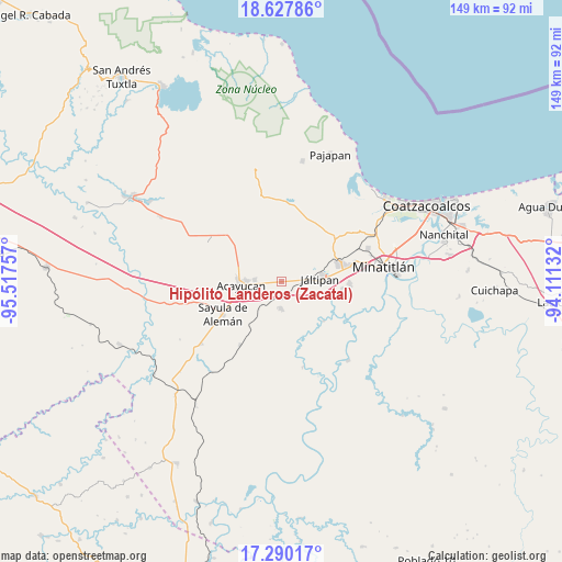
| Upper-left | 18.62786°, | -95.51757° |
| Center: | 17.96028°, | -94.81444° |
| Lower-right: | 17.29017°, | -94.11132° |
| Map W x H: | 148.7×148.7 km | = 92.4×92.4mi |
| max Lat: | 32.7° ⇑79.1% North |
| Hipólito Landeros (Zacatal): | 17.96028° |
| min Lat: | ⇓20.9% South 14.53588° |
| min Long | Hipólito Lande | max Long |
| -117.105° | -94.81444° | -86.73105° |
| W 85%⇐ | ⇒15% E |
Elevation
Elevation of Hipólito Landeros (Zacatal) is 48 m = 157 ft, and this is 1205.7 m = 3956 ft below average elevation for this country.
| Max E: |
3497 m = 11473 ft | 84.5% |
| Avg. | 1253.7 m = 4113 ft | |
| Hipólito Landeros (Zacatal) | 48 m = 157 ft | |
Min E: |
-1 m = -3 ft | 15.5% |
See also: Mexico elevation on elevation.city.
Geographical zone
Hipólito Landeros (Zacatal) is located in North Torrid zone (between Equator and Tropic of Cancer). Distance of this Northern Tropic circle is 608.9 km =378.4 mi to North.| Distance of | km | miles | from Hipólito Landeros (Zacatal) |
|---|---|---|---|
| North Pole | 8010.1 | 4977.2 | to North |
| Arctic Circle | 5404.2 | 3358 | to North |
| Tropic Cancer | 608.9 | 378.4 | to North |
| Equator | 1997 | 1240.9 | to South |


Nearby cities:
15 places around Hipólito Landeros (Zacatal): (largest is in red/bold)
• Acayucan
10.6 km =6.6 mi,  263°
263°
• Agua Fría
13 km =8.1 mi,  36°
36°
• Chalcomulco
7.3 km =4.5 mi,  27°
27°
• Cirilo Vázquez Lagunes
11.4 km =7.1 mi,  285°
285°
• Colonia Lealtad
9.3 km =5.8 mi,  271°
271°
• Fraccionamiento Santa Cruz
8.6 km =5.3 mi,  278°
278°
• Francisco I. Madero
3.7 km =2.3 mi,  253°
253°
• Ixhuapan
8.8 km =5.5 mi,  311°
311°
• Jáltipan de Morelos
10.6 km =6.6 mi,  86°
86°
• Monte Grande
12.9 km =8 mi,  320°
320°
• Oluta
9.3 km =5.8 mi, 248°
• Soconusco
7 km =4.3 mi, 272°
• Tecuanapa
11.6 km =7.2 mi, 294°
• Tenejapa
9.4 km =5.8 mi,  218°
218°
• Texistepec
7.3 km =4.5 mi,  182°
182°
Sources, notices
• [Note1] Compared only with cities in Mexico existing in our database
• [Src1] Map data: © OpenStreetMap contributors (CC-BY-SA)
• [Src2] Other city data from geonames.org with taken over terms of usage.
• [Src3] Geographical zone / Annual Mean Temperature by Robert A. Rohde @ Wikipedia
