Tenejapa geodata
Tenejapa (Veracruz) is a populated place; located in Mexico in America/Mexico_City (GMT-6) time zone. With population of 533 people, there are 15888 cities with bigger population in this country. Compared to other cities in Mexico, 79.8% of cities are located further ↑North; 84.9% of cities are located further ←West and 88% of cities have higher elevation than Tenejapa. Note1


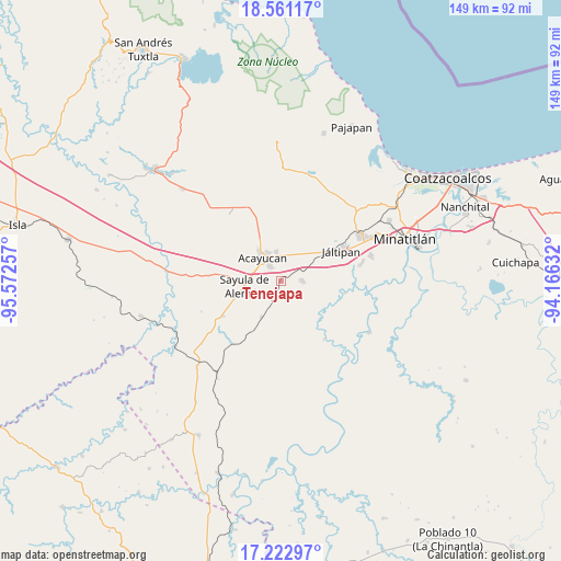
Tenejapa GPS coordinates[2]
17° 53' 35.988" North, 94° 52' 9.984" West
| Map corner | latitude | longitude |
|---|---|---|
| Upper-left | 18.56117°, | -95.57257° |
| Center: | 17.89333°, | -94.86944° |
| Lower-right: | 17.22297°, | -94.16632° |
| Map W x H: | 148.8×148.8 km | = 92.5×92.5mi |
| max Lat: | 32.7° ⇑79.8% North |
| Tenejapa: | 17.89333° |
| min Lat: | ⇓20.2% South 14.53588° |
| min Long | Tenejapa | max Long |
| -117.105° | -94.86944° | -86.73105° |
| W 84.9%⇐ | ⇒15.1% E |
Elevation
Elevation of Tenejapa is 30 m = 98 ft, and this is 1223.7 m = 4015 ft below average elevation for this country.
| Max E: |
3497 m = 11473 ft | 88% |
| Avg. | 1253.7 m = 4113 ft | |
| Tenejapa | 30 m = 98 ft | |
Min E: |
-1 m = -3 ft | 12% |
See also: Mexico elevation on elevation.city.
Geographical zone
Tenejapa is located in North Torrid zone (between Equator and Tropic of Cancer). Distance of this Northern Tropic circle is 616.4 km =383 mi to North.| Distance of | km | miles | from Tenejapa |
|---|---|---|---|
| North Pole | 8017.5 | 4981.8 | to North |
| Arctic Circle | 5411.6 | 3362.6 | to North |
| Tropic Cancer | 616.4 | 383 | to North |
| Equator | 1989.6 | 1236.3 | to South |


Nearby cities:
15 places around Tenejapa: (largest is in red/bold)
• Acayucan
7.8 km =4.8 mi,  323°
323°
• Almagres
10.8 km =6.7 mi,  208°
208°
• Cirilo Vázquez Lagunes
11.6 km =7.2 mi,  333°
333°
• Colonia Lealtad
8.5 km =5.3 mi,  335°
335°
• Congregación Hidalgo
11.8 km =7.3 mi,  294°
294°
• Fraccionamiento Santa Cruz
9.1 km =5.7 mi, 342°
• Francisco I. Madero
6.8 km =4.2 mi,  19°
19°
• Hipólito Landeros (Zacatal)
9.4 km =5.8 mi,  38°
38°
• Ixhuapan
13.4 km =8.3 mi,  356°
356°
• Nuevo Poblado el Hato
11.6 km =7.2 mi, 294°
• Oluta
5 km =3.1 mi, 324°
• Sayula de Alemán
9.7 km =6 mi,  262°
262°
• Soconusco
7.9 km =4.9 mi,  351°
351°
• Tecuanapa
13.2 km =8.2 mi, 339°
• Texistepec
5.5 km =3.4 mi,  88°
88°
Sources, notices
• [Note1] Compared only with cities in Mexico existing in our database
• [Src1] Map data: © OpenStreetMap contributors (CC-BY-SA)
• [Src2] Other city data from geonames.org with taken over terms of usage.
• [Src3] Geographical zone / Annual Mean Temperature by Robert A. Rohde @ Wikipedia
