Acayucan geodata
Acayucan (Veracruz) is a seat of a second-order administrative division; located in Mexico in America/Mexico_City (GMT-6) time zone. With population of 50,934 people, there are 222 cities with bigger population in this country. Compared to other cities in Mexico, 79.2% of cities are located further ↑North; 84.8% of cities are located further ←West and 79.5% of cities have higher elevation than Acayucan. Note1


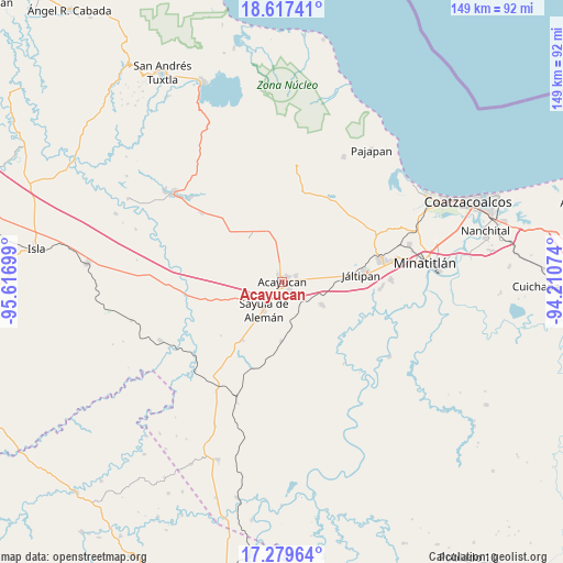
Acayucan GPS coordinates[2]
17° 56' 59.244" North, 94° 54' 49.896" West
| Map corner | latitude | longitude |
|---|---|---|
| Upper-left | 18.61741°, | -95.61699° |
| Center: | 17.94979°, | -94.91386° |
| Lower-right: | 17.27964°, | -94.21074° |
| Map W x H: | 148.7×148.7 km | = 92.4×92.4mi |
| max Lat: | 32.7° ⇑79.2% North |
| Acayucan: | 17.94979° |
| min Lat: | ⇓20.8% South 14.53588° |
| min Long | Acayucan | max Long |
| -117.105° | -94.91386° | -86.73105° |
| W 84.8%⇐ | ⇒15.2% E |
Elevation
Elevation of Acayucan is 102 m = 335 ft, and this is 1151.7 m = 3779 ft below average elevation for this country.
| Max E: |
3497 m = 11473 ft | 79.5% |
| Avg. | 1253.7 m = 4113 ft | |
| Acayucan | 102 m = 335 ft | |
Min E: |
-1 m = -3 ft | 20.5% |
See also: Acayucan elevation on elevation.city.
Geographical zone
Acayucan is located in North Torrid zone (between Equator and Tropic of Cancer). Distance of this Northern Tropic circle is 610.1 km =379.1 mi to North.| Distance of | km | miles | from Acayucan |
|---|---|---|---|
| North Pole | 8011.2 | 4977.9 | to North |
| Arctic Circle | 5405.3 | 3358.7 | to North |
| Tropic Cancer | 610.1 | 379.1 | to North |
| Equator | 1995.8 | 1240.1 | to South |


Nearby cities:
15 places around Acayucan: (largest is in red/bold)
• Cirilo Vázquez Lagunes
4.2 km =2.6 mi,  353°
353°
• Colonia Lealtad
1.9 km =1.2 mi,  39°
39°
• Congregación Hidalgo
6.2 km =3.9 mi,  257°
257°
• Dehesa
9 km =5.6 mi, 264°
• El Hato
7.2 km =4.5 mi,  315°
315°
• Fraccionamiento Santa Cruz
3.2 km =2 mi, 39°
• Francisco I. Madero
7 km =4.3 mi,  89°
89°
• Hipólito Landeros (Zacatal)
10.6 km =6.6 mi,  83°
83°
• Ixhuapan
8.1 km =5 mi,  29°
29°
• Nuevo Poblado el Hato
6 km =3.7 mi, 255°
• Oluta
2.9 km =1.8 mi,  140°
140°
• Sayula de Alemán
9 km =5.6 mi,  212°
212°
• Soconusco
3.8 km =2.4 mi,  66°
66°
• Tecuanapa
6.1 km =3.8 mi,  0°
0°
• Tenejapa
7.8 km =4.8 mi, 143°
Sources, notices
• [Note1] Compared only with cities in Mexico existing in our database
• [Src1] Map data: © OpenStreetMap contributors (CC-BY-SA)
• [Src2] Other city data from geonames.org with taken over terms of usage.
• [Src3] Geographical zone / Annual Mean Temperature by Robert A. Rohde @ Wikipedia
