Tepatlán geodata
Tepatlán (Veracruz) is a populated place; located in Mexico in America/Mexico_City (GMT-6) time zone. With population of 554 people, there are 15392 cities with bigger population in this country. Compared to other cities in Mexico, 80% of cities are located further ↓South; 60.3% of cities are located further ←West and 80.5% of cities have higher elevation than Tepatlán. Note1


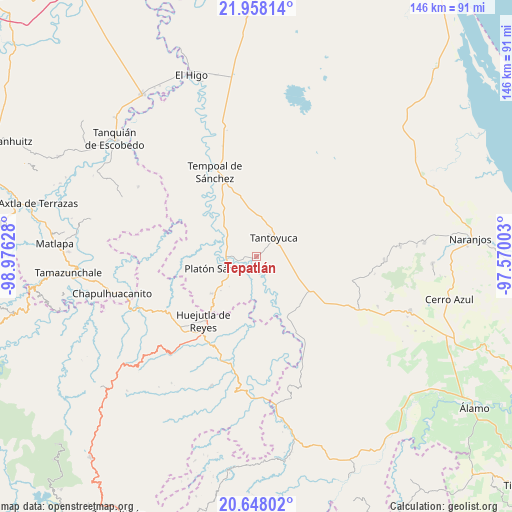
Tepatlán GPS coordinates[2]
21° 18' 16.344" North, 98° 16' 23.34" West
| Map corner | latitude | longitude |
|---|---|---|
| Upper-left | 21.95814°, | -98.97628° |
| Center: | 21.30454°, | -98.27315° |
| Lower-right: | 20.64802°, | -97.57003° |
| Map W x H: | 145.7×145.7 km | = 90.5×90.5mi |
| max Lat: | 32.7° ⇑20% North |
| Tepatlán: | 21.30454° |
| min Lat: | ⇓80% South 14.53588° |
| min Long | Tepatlán | max Long |
| -117.105° | -98.27315° | -86.73105° |
| W 60.3%⇐ | ⇒39.7% E |
Elevation
Elevation of Tepatlán is 88 m = 289 ft, and this is 1165.7 m = 3824 ft below average elevation for this country.
| Max E: |
3497 m = 11473 ft | 80.5% |
| Avg. | 1253.7 m = 4113 ft | |
| Tepatlán | 88 m = 289 ft | |
Min E: |
-1 m = -3 ft | 19.5% |
See also: Mexico elevation on elevation.city.
Geographical zone
Tepatlán is located in North Torrid zone (between Equator and Tropic of Cancer). Distance of this Northern Tropic circle is 237.1 km =147.3 mi to North.| Distance of | km | miles | from Tepatlán |
|---|---|---|---|
| North Pole | 7638.2 | 4746.2 | to North |
| Arctic Circle | 5032.3 | 3126.9 | to North |
| Tropic Cancer | 237.1 | 147.3 | to North |
| Equator | 2368.8 | 1471.9 | to South |


Nearby cities:
15 places around Tepatlán: (largest is in red/bold)
• Cerro Botica
11.9 km =7.4 mi,  3°
3°
• Ciruelar Aquiche
11.9 km =7.4 mi,  339°
339°
• Corralillo
8.1 km =5 mi,  133°
133°
• El Jobo Aquiche
9.9 km =6.2 mi, 342°
• El Lindero
5.6 km =3.5 mi,  80°
80°
• El Mirador
10.9 km =6.8 mi,  138°
138°
• El Remanso
8.2 km =5.1 mi,  267°
267°
• Moralillo
6.6 km =4.1 mi,  103°
103°
• Palmar Aquiche Primero
10.5 km =6.5 mi,  350°
350°
• Platón Sánchez
11.1 km =6.9 mi,  250°
250°
• Potrero Segundo
5.5 km =3.4 mi, 4°
• Tametate
4.5 km =2.8 mi,  69°
69°
• Tantoyuca
7.1 km =4.4 mi,  43°
43°
• Trapiche
7.3 km =4.5 mi, 354°
• Xiloxúchitl
4.7 km =2.9 mi, 2°
Sources, notices
• [Note1] Compared only with cities in Mexico existing in our database
• [Src1] Map data: © OpenStreetMap contributors (CC-BY-SA)
• [Src2] Other city data from geonames.org with taken over terms of usage.
• [Src3] Geographical zone / Annual Mean Temperature by Robert A. Rohde @ Wikipedia
