La Reforma geodata
La Reforma (Veracruz) is a populated place; located in Mexico in America/Mexico_City (GMT-6) time zone. With population of 612 people, there are 14088 cities with bigger population in this country. Compared to other cities in Mexico, 73.5% of cities are located further ↓South; 62% of cities are located further ←West and 71% of cities have higher elevation than La Reforma. Note1


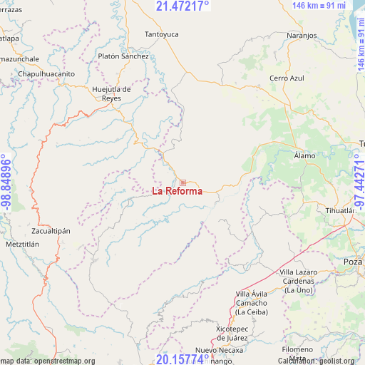
La Reforma GPS coordinates[2]
20° 48' 59.004" North, 98° 8' 44.988" West
| Map corner | latitude | longitude |
|---|---|---|
| Upper-left | 21.47217°, | -98.84896° |
| Center: | 20.81639°, | -98.14583° |
| Lower-right: | 20.15774°, | -97.44271° |
| Map W x H: | 146.2×146.2 km | = 90.8×90.8mi |
| max Lat: | 32.7° ⇑26.5% North |
| La Reforma: | 20.81639° |
| min Lat: | ⇓73.5% South 14.53588° |
| min Long | La Reforma | max Long |
| -117.105° | -98.14583° | -86.73105° |
| W 62%⇐ | ⇒38% E |
Elevation
Elevation of La Reforma is 372 m = 1220 ft, and this is 881.7 m = 2893 ft below average elevation for this country.
| Max E: |
3497 m = 11473 ft | 71% |
| Avg. | 1253.7 m = 4113 ft | |
| La Reforma | 372 m = 1220 ft | |
Min E: |
-1 m = -3 ft | 29% |
See also: Mexico elevation on elevation.city.
Geographical zone
La Reforma is located in North Torrid zone (between Equator and Tropic of Cancer). Distance of this Northern Tropic circle is 291.4 km =181.1 mi to North.| Distance of | km | miles | from La Reforma |
|---|---|---|---|
| North Pole | 7692.5 | 4779.9 | to North |
| Arctic Circle | 5086.6 | 3160.7 | to North |
| Tropic Cancer | 291.4 | 181.1 | to North |
| Equator | 2314.6 | 1438.2 | to South |


Nearby cities:
15 places around La Reforma: (largest is in red/bold)
• Benito Juárez
10 km =6.2 mi,  321°
321°
• Calaco
8.8 km =5.5 mi,  332°
332°
• Colatlán
5.1 km =3.2 mi,  89°
89°
• El Limón
10.3 km =6.4 mi,  76°
76°
• El Naranjal
9.9 km =6.2 mi,  191°
191°
• El Tizán
10.1 km =6.3 mi,  126°
126°
• Huexotitla
7.9 km =4.9 mi, 131°
• Hueycuatitla
6.5 km =4 mi, 331°
• Otlamalacatl
8.3 km =5.2 mi,  283°
283°
• Palma Real
1.6 km =1 mi,  136°
136°
• Pemuxtitla
10.3 km =6.4 mi,  355°
355°
• Pilpuerta
4.9 km =3 mi,  145°
145°
• Primo Verdad
7.2 km =4.5 mi,  274°
274°
• Tenantitla
5.1 km =3.2 mi,  178°
178°
• Xochimilco
9.5 km =5.9 mi,  56°
56°
Sources, notices
• [Note1] Compared only with cities in Mexico existing in our database
• [Src1] Map data: © OpenStreetMap contributors (CC-BY-SA)
• [Src2] Other city data from geonames.org with taken over terms of usage.
• [Src3] Geographical zone / Annual Mean Temperature by Robert A. Rohde @ Wikipedia
