Hueycuatitla geodata
Hueycuatitla (Veracruz) is a populated place; located in Mexico in America/Mexico_City (GMT-6) time zone. With population of 950 people, there are 9169 cities with bigger population in this country. Compared to other cities in Mexico, 74.2% of cities are located further ↓South; 61.6% of cities are located further ←West and 72.6% of cities have higher elevation than Hueycuatitla. Note1


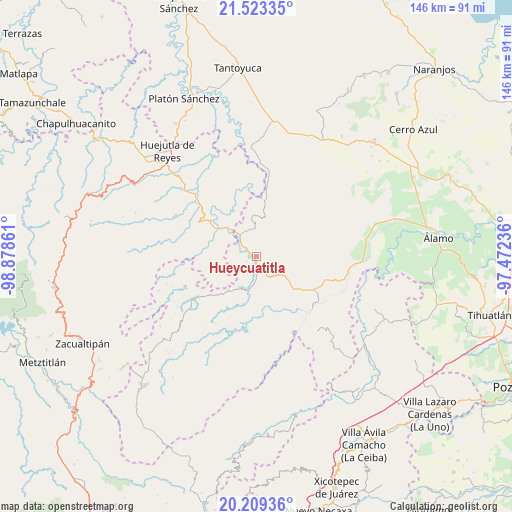
Hueycuatitla GPS coordinates[2]
20° 52' 4.044" North, 98° 10' 31.728" West
| Map corner | latitude | longitude |
|---|---|---|
| Upper-left | 21.52335°, | -98.87861° |
| Center: | 20.86779°, | -98.17548° |
| Lower-right: | 20.20936°, | -97.47236° |
| Map W x H: | 146.1×146.1 km | = 90.8×90.8mi |
| max Lat: | 32.7° ⇑25.8% North |
| Hueycuatitla: | 20.86779° |
| min Lat: | ⇓74.2% South 14.53588° |
| min Long | Hueycuatitla | max Long |
| -117.105° | -98.17548° | -86.73105° |
| W 61.6%⇐ | ⇒38.4% E |
Elevation
Elevation of Hueycuatitla is 306 m = 1004 ft, and this is 947.7 m = 3109 ft below average elevation for this country.
| Max E: |
3497 m = 11473 ft | 72.6% |
| Avg. | 1253.7 m = 4113 ft | |
| Hueycuatitla | 306 m = 1004 ft | |
Min E: |
-1 m = -3 ft | 27.4% |
See also: Mexico elevation on elevation.city.
Geographical zone
Hueycuatitla is located in North Torrid zone (between Equator and Tropic of Cancer). Distance of this Northern Tropic circle is 285.6 km =177.5 mi to North.| Distance of | km | miles | from Hueycuatitla |
|---|---|---|---|
| North Pole | 7686.8 | 4776.4 | to North |
| Arctic Circle | 5080.9 | 3157.1 | to North |
| Tropic Cancer | 285.6 | 177.5 | to North |
| Equator | 2320.3 | 1441.8 | to South |


Nearby cities:
15 places around Hueycuatitla: (largest is in red/bold)
• Acatitla
10 km =6.2 mi,  348°
348°
• Ahuica
7 km =4.3 mi,  358°
358°
• Alahualtitla
6.7 km =4.2 mi,  7°
7°
• Benito Juárez
3.8 km =2.4 mi,  303°
303°
• Calaco
2.3 km =1.4 mi,  333°
333°
• Colatlán
10 km =6.2 mi,  124°
124°
• La Reforma
6.5 km =4 mi,  151°
151°
• Nanayatla
10.2 km =6.3 mi,  241°
241°
• Ohuatipa
9.4 km =5.8 mi,  287°
287°
• Otlamalacatl
6.3 km =3.9 mi,  232°
232°
• Palma Real
8.1 km =5 mi, 148°
• Pemuxtitla
5.2 km =3.2 mi,  26°
26°
• Primo Verdad
6.6 km =4.1 mi,  218°
218°
• Sasaltitla
7.8 km =4.8 mi,  343°
343°
• Texoloc
9.8 km =6.1 mi, 304°
Sources, notices
• [Note1] Compared only with cities in Mexico existing in our database
• [Src1] Map data: © OpenStreetMap contributors (CC-BY-SA)
• [Src2] Other city data from geonames.org with taken over terms of usage.
• [Src3] Geographical zone / Annual Mean Temperature by Robert A. Rohde @ Wikipedia
