Plan de Hidalgo geodata
Plan de Hidalgo (Veracruz) is a populated place; located in Mexico in America/Mexico_City (GMT-6) time zone. With population of 995 people, there are 8755 cities with bigger population in this country. Compared to other cities in Mexico, 65.7% of cities are located further ↓South; 70.1% of cities are located further ←West and 77.5% of cities have higher elevation than Plan de Hidalgo. Note1


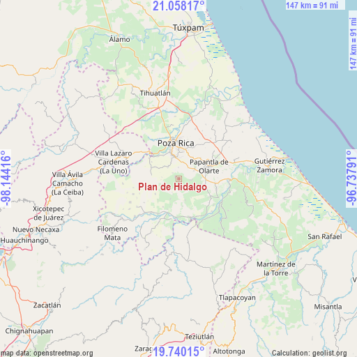
Plan de Hidalgo GPS coordinates[2]
20° 24' 2.052" North, 97° 26' 27.708" West
| Map corner | latitude | longitude |
|---|---|---|
| Upper-left | 21.05817°, | -98.14416° |
| Center: | 20.40057°, | -97.44103° |
| Lower-right: | 19.74015°, | -96.73791° |
| Map W x H: | 146.6×146.6 km | = 91.1×91.1mi |
| max Lat: | 32.7° ⇑34.3% North |
| Plan de Hidalgo: | 20.40057° |
| min Lat: | ⇓65.7% South 14.53588° |
| min Long | Plan de Hidalgo | max Long |
| -117.105° | -97.44103° | -86.73105° |
| W 70.1%⇐ | ⇒29.9% E |
Elevation
Elevation of Plan de Hidalgo is 141 m = 463 ft, and this is 1112.7 m = 3651 ft below average elevation for this country.
| Max E: |
3497 m = 11473 ft | 77.5% |
| Avg. | 1253.7 m = 4113 ft | |
| Plan de Hidalgo | 141 m = 463 ft | |
Min E: |
-1 m = -3 ft | 22.5% |
See also: Mexico elevation on elevation.city.
Geographical zone
Plan de Hidalgo is located in North Torrid zone (between Equator and Tropic of Cancer). Distance of this Northern Tropic circle is 337.6 km =209.8 mi to North.| Distance of | km | miles | from Plan de Hidalgo |
|---|---|---|---|
| North Pole | 7738.7 | 4808.6 | to North |
| Arctic Circle | 5132.8 | 3189.4 | to North |
| Tropic Cancer | 337.6 | 209.8 | to North |
| Equator | 2268.3 | 1409.5 | to South |


Nearby cities:
15 places around Plan de Hidalgo: (largest is in red/bold)
• Coatzintla
10 km =6.2 mi,  343°
343°
• Congregación el Tajín
7 km =4.3 mi,  61°
61°
• El Chote
10.1 km =6.3 mi,  89°
89°
• Escolín de Olarte
11 km =6.8 mi,  9°
9°
• Francisco Sarabia
8.6 km =5.3 mi,  238°
238°
• Gildardo Muñoz
5.2 km =3.2 mi,  96°
96°
• José María Morelos
9.2 km =5.7 mi,  163°
163°
• La Laguna
4.7 km =2.9 mi,  357°
357°
• Manuel María Contreras
6.7 km =4.2 mi,  319°
319°
• Plan del Palmar
1.7 km =1.1 mi,  296°
296°
• Poza Larga Zapotal
9 km =5.6 mi,  203°
203°
• Santa Catarina y Ciruelo
11.1 km =6.9 mi, 198°
• Tlahuanapa
8.2 km =5.1 mi,  80°
80°
• Troncones y Potrerillos
9.2 km =5.7 mi, 339°
• Vista Hermosa de Madero
3.4 km =2.1 mi, 163°
Sources, notices
• [Note1] Compared only with cities in Mexico existing in our database
• [Src1] Map data: © OpenStreetMap contributors (CC-BY-SA)
• [Src2] Other city data from geonames.org with taken over terms of usage.
• [Src3] Geographical zone / Annual Mean Temperature by Robert A. Rohde @ Wikipedia
