La Sombra geodata
La Sombra (Veracruz) is a populated place; located in Mexico in America/Mexico_City (GMT-6) time zone. With population of 1,042 people, there are 8364 cities with bigger population in this country. Compared to other cities in Mexico, 51.5% of cities are located further ↓South; 78.3% of cities are located further ←West and 54.5% of cities have higher elevation than La Sombra. Note1


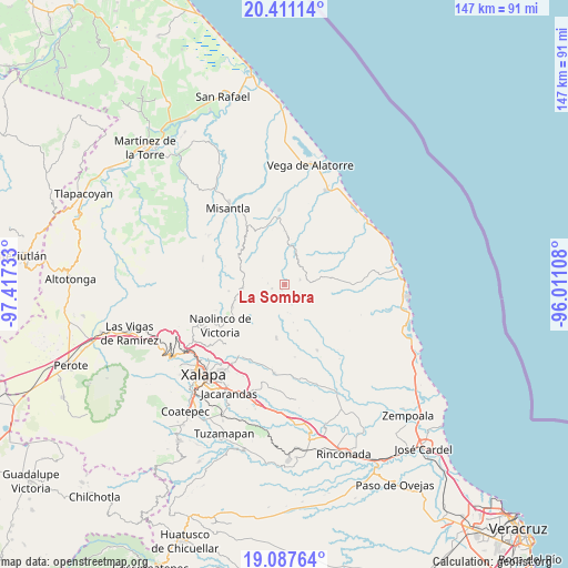
La Sombra GPS coordinates[2]
19° 45' 2.736" North, 96° 42' 51.12" West
| Map corner | latitude | longitude |
|---|---|---|
| Upper-left | 20.41114°, | -97.41733° |
| Center: | 19.75076°, | -96.7142° |
| Lower-right: | 19.08764°, | -96.01108° |
| Map W x H: | 147.2×147.2 km | = 91.5×91.5mi |
| max Lat: | 32.7° ⇑48.5% North |
| La Sombra: | 19.75076° |
| min Lat: | ⇓51.5% South 14.53588° |
| min Long | La Sombra | max Long |
| -117.105° | -96.7142° | -86.73105° |
| W 78.3%⇐ | ⇒21.7% E |
Elevation
Elevation of La Sombra is 1221 m = 4006 ft, and this is 32.7 m = 107 ft below average elevation for this country.
| Max E: |
3497 m = 11473 ft | 54.5% |
| Avg. | 1253.7 m = 4113 ft | |
| La Sombra | 1221 m = 4006 ft | |
Min E: |
-1 m = -3 ft | 45.5% |
See also: Mexico elevation on elevation.city.
Geographical zone
La Sombra is located in North Torrid zone (between Equator and Tropic of Cancer). Distance of this Northern Tropic circle is 409.8 km =254.6 mi to North.| Distance of | km | miles | from La Sombra |
|---|---|---|---|
| North Pole | 7811 | 4853.5 | to North |
| Arctic Circle | 5205.1 | 3234.3 | to North |
| Tropic Cancer | 409.8 | 254.6 | to North |
| Equator | 2196.1 | 1364.6 | to South |


Nearby cities:
15 places around La Sombra: (largest is in red/bold)
• Chiconquiaco
11 km =6.8 mi,  264°
264°
• Cuautitlán del Parral
10.5 km =6.5 mi,  349°
349°
• El Cafetal
7.3 km =4.5 mi,  174°
174°
• El Capulín
1.7 km =1.1 mi,  203°
203°
• El Escalanar
2.6 km =1.6 mi,  206°
206°
• El Huérfano
3.4 km =2.1 mi,  251°
251°
• Enríquez
8.5 km =5.3 mi, 201°
• Juchique de Ferrer
10.1 km =6.3 mi,  11°
11°
• Laguna de Farfán
9.4 km =5.8 mi,  51°
51°
• Mafafas
11.1 km =6.9 mi, 203°
• Monte Verde Chivería
5.6 km =3.5 mi,  160°
160°
• Plan de las Hayas
4.1 km =2.5 mi,  76°
76°
• Rancho Nuevo
4.8 km =3 mi,  118°
118°
• Tierra Blanca
5.3 km =3.3 mi,  130°
130°
• Xomotla
8.2 km =5.1 mi,  186°
186°
Sources, notices
• [Note1] Compared only with cities in Mexico existing in our database
• [Src1] Map data: © OpenStreetMap contributors (CC-BY-SA)
• [Src2] Other city data from geonames.org with taken over terms of usage.
• [Src3] Geographical zone / Annual Mean Temperature by Robert A. Rohde @ Wikipedia
