Enríquez geodata
Enríquez (Veracruz) is a populated place; located in Mexico in America/Mexico_City (GMT-6) time zone. With population of 770 people, there are 11354 cities with bigger population in this country. Compared to other cities in Mexico, 50.2% of cities are located further ↑North; 77.9% of cities are located further ←West and 55% of cities have higher elevation than Enríquez. Note1


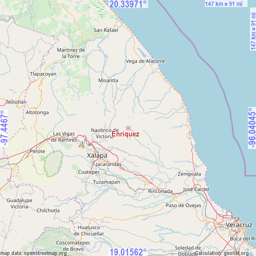
Enríquez GPS coordinates[2]
19° 40' 44.508" North, 96° 44' 36.852" West
| Map corner | latitude | longitude |
|---|---|---|
| Upper-left | 20.33971°, | -97.4467° |
| Center: | 19.67903°, | -96.74357° |
| Lower-right: | 19.01562°, | -96.04045° |
| Map W x H: | 147.2×147.2 km | = 91.5×91.5mi |
| max Lat: | 32.7° ⇑50.2% North |
| Enríquez: | 19.67903° |
| min Lat: | ⇓49.8% South 14.53588° |
| min Long | Enríquez | max Long |
| -117.105° | -96.74357° | -86.73105° |
| W 77.9%⇐ | ⇒22.1% E |
Elevation
Elevation of Enríquez is 1198 m = 3930 ft, and this is 55.7 m = 183 ft below average elevation for this country.
| Max E: |
3497 m = 11473 ft | 55% |
| Avg. | 1253.7 m = 4113 ft | |
| Enríquez | 1198 m = 3930 ft | |
Min E: |
-1 m = -3 ft | 45% |
See also: Mexico elevation on elevation.city.
Geographical zone
Enríquez is located in North Torrid zone (between Equator and Tropic of Cancer). Distance of this Northern Tropic circle is 417.8 km =259.6 mi to North.| Distance of | km | miles | from Enríquez |
|---|---|---|---|
| North Pole | 7819 | 4858.5 | to North |
| Arctic Circle | 5213.1 | 3239.3 | to North |
| Tropic Cancer | 417.8 | 259.6 | to North |
| Equator | 2188.1 | 1359.6 | to South |


Nearby cities:
15 places around Enríquez: (largest is in red/bold)
• Alto Lucero
6.2 km =3.9 mi,  170°
170°
• Cerrillos de Diaz
5.9 km =3.7 mi,  160°
160°
• El Cafetal
3.9 km =2.4 mi,  79°
79°
• El Capulín
6.8 km =4.2 mi,  20°
20°
• El Escalanar
5.9 km =3.7 mi, 18°
• El Huérfano
6.9 km =4.3 mi,  358°
358°
• La Sombra
8.5 km =5.3 mi, 21°
• Las Haldas
10.2 km =6.3 mi,  236°
236°
• Mafafas
2.6 km =1.6 mi,  209°
209°
• Monte Verde Chivería
5.6 km =3.5 mi,  61°
61°
• Rancho Nuevo
9.2 km =5.7 mi,  51°
51°
• Tepetlán
5.7 km =3.5 mi,  263°
263°
• Tierra Blanca
8.5 km =5.3 mi, 57°
• Vicente Guerrero (Tepetates)
10.1 km =6.3 mi,  221°
221°
• Xomotla
2.1 km =1.3 mi,  94°
94°
Sources, notices
• [Note1] Compared only with cities in Mexico existing in our database
• [Src1] Map data: © OpenStreetMap contributors (CC-BY-SA)
• [Src2] Other city data from geonames.org with taken over terms of usage.
• [Src3] Geographical zone / Annual Mean Temperature by Robert A. Rohde @ Wikipedia
