El Escalanar geodata
El Escalanar (Veracruz) is a populated place; located in Mexico in America/Mexico_City (GMT-6) time zone. With population of 658 people, there are 13187 cities with bigger population in this country. Compared to other cities in Mexico, 51.1% of cities are located further ↓South; 78.1% of cities are located further ←West and 51.7% of cities have higher elevation than El Escalanar. Note1


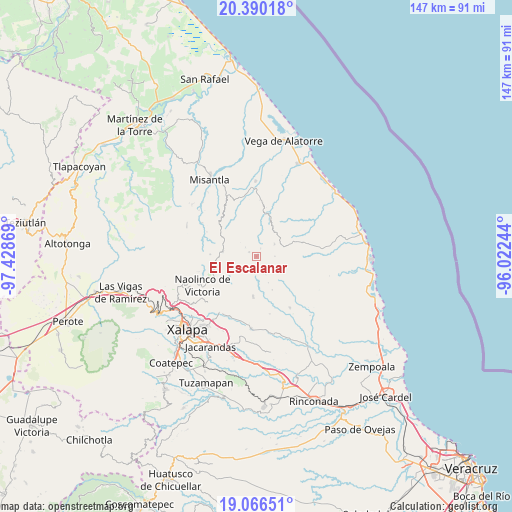
El Escalanar GPS coordinates[2]
19° 43' 46.992" North, 96° 43' 32.016" West
| Map corner | latitude | longitude |
|---|---|---|
| Upper-left | 20.39018°, | -97.42869° |
| Center: | 19.72972°, | -96.72556° |
| Lower-right: | 19.06651°, | -96.02244° |
| Map W x H: | 147.2×147.2 km | = 91.5×91.5mi |
| max Lat: | 32.7° ⇑48.9% North |
| El Escalanar: | 19.72972° |
| min Lat: | ⇓51.1% South 14.53588° |
| min Long | El Escalanar | max Long |
| -117.105° | -96.72556° | -86.73105° |
| W 78.1%⇐ | ⇒21.9% E |
Elevation
Elevation of El Escalanar is 1352 m = 4436 ft, and this is 98.3 m = 323 ft above average elevation for this country.
| Max E: |
3497 m = 11473 ft | 51.7% |
| El Escalanar | 1352 m 4436 ft | |
| Avg. | 1253.7 m = 4113 ft | |
Min E: |
-1 m = -3 ft | 48.3% |
See also: Mexico elevation on elevation.city.
Geographical zone
El Escalanar is located in North Torrid zone (between Equator and Tropic of Cancer). Distance of this Northern Tropic circle is 412.2 km =256.1 mi to North.| Distance of | km | miles | from El Escalanar |
|---|---|---|---|
| North Pole | 7813.3 | 4855 | to North |
| Arctic Circle | 5207.4 | 3235.7 | to North |
| Tropic Cancer | 412.2 | 256.1 | to North |
| Equator | 2193.7 | 1363.1 | to South |


Nearby cities:
15 places around El Escalanar: (largest is in red/bold)
• Alto Lucero
11.7 km =7.3 mi,  184°
184°
• Cerrillos de Diaz
11.2 km =7 mi, 179°
• Chiconquiaco
9.8 km =6.1 mi,  278°
278°
• El Cafetal
5.3 km =3.3 mi,  158°
158°
• El Capulín
0.9 km =0.6 mi,  34°
34°
• El Huérfano
2.4 km =1.5 mi,  300°
300°
• Enríquez
5.9 km =3.7 mi,  198°
198°
• La Sombra
2.6 km =1.6 mi, 26°
• Mafafas
8.5 km =5.3 mi, 201°
• Monte Verde Chivería
4.3 km =2.7 mi,  133°
133°
• Plan de las Hayas
6.2 km =3.9 mi,  57°
57°
• Rancho Nuevo
5.4 km =3.4 mi,  89°
89°
• Tepetlán
9.8 km =6.1 mi,  230°
230°
• Tierra Blanca
5.4 km =3.4 mi,  101°
101°
• Xomotla
5.8 km =3.6 mi, 177°
Sources, notices
• [Note1] Compared only with cities in Mexico existing in our database
• [Src1] Map data: © OpenStreetMap contributors (CC-BY-SA)
• [Src2] Other city data from geonames.org with taken over terms of usage.
• [Src3] Geographical zone / Annual Mean Temperature by Robert A. Rohde @ Wikipedia
