La Campana geodata
La Campana (Veracruz) is a populated place; located in Mexico in America/Mexico_City (GMT-6) time zone. With population of 932 people, there are 9352 cities with bigger population in this country. Compared to other cities in Mexico, 69.7% of cities are located further ↑North; 80% of cities are located further ←West and 79.5% of cities have higher elevation than La Campana. Note1


La Campana GPS coordinates[2]
18° 44' 18.924" North, 96° 27' 12.024" West
| Map corner | latitude | longitude |
|---|---|---|
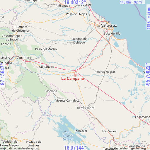
| Upper-left | 19.40312°, | -97.15647° |
| Center: | 18.73859°, | -96.45334° |
| Lower-right: | 18.07144°, | -95.75022° |
| Map W x H: | 148.1×148.1 km | = 92×92mi |
| max Lat: | 32.7° ⇑69.7% North |
| La Campana: | 18.73859° |
| min Lat: | ⇓30.3% South 14.53588° |
| min Long | La Campana | max Long |
| -117.105° | -96.45334° | -86.73105° |
| W 80%⇐ | ⇒20% E |
Elevation
Elevation of La Campana is 102 m = 335 ft, and this is 1151.7 m = 3779 ft below average elevation for this country.
| Max E: |
3497 m = 11473 ft | 79.5% |
| Avg. | 1253.7 m = 4113 ft | |
| La Campana | 102 m = 335 ft | |
Min E: |
-1 m = -3 ft | 20.5% |
See also: Mexico elevation on elevation.city.
Geographical zone
La Campana is located in North Torrid zone (between Equator and Tropic of Cancer). Distance of this Northern Tropic circle is 522.4 km =324.6 mi to North.| Distance of | km | miles | from La Campana |
|---|---|---|---|
| North Pole | 7923.5 | 4923.4 | to North |
| Arctic Circle | 5317.6 | 3304.2 | to North |
| Tropic Cancer | 522.4 | 324.6 | to North |
| Equator | 2083.5 | 1294.6 | to South |


Nearby cities:
15 places around La Campana: (largest is in red/bold)
• Bajo Grande
17.8 km =11.1 mi,  269°
269°
• Cerro Alto
8.6 km =5.3 mi,  305°
305°
• Colonia Primero de Mayo
18.8 km =11.7 mi,  244°
244°
• Cotaxtla
12.3 km =7.6 mi,  29°
29°
• Cuyucuenda
19.5 km =12.1 mi,  75°
75°
• El Quechuleño
18.9 km =11.7 mi,  177°
177°
• Huixcolotla
9.4 km =5.8 mi,  209°
209°
• La Tinaja
2.7 km =1.7 mi,  337°
337°
• Loma Mulato
16.5 km =10.3 mi,  262°
262°
• Los Mangos
15 km =9.3 mi,  143°
143°
• Mata Gallina
19.3 km =12 mi,  298°
298°
• Mata Tejón
19 km =11.8 mi,  18°
18°
• Paso Coyote
18.7 km =11.6 mi,  134°
134°
• Rodríguez Tejeda
12.5 km =7.8 mi,  161°
161°
• Salvador Gonzalo García
12.6 km =7.8 mi, 162°
Sources, notices
• [Note1] Compared only with cities in Mexico existing in our database
• [Src1] Map data: © OpenStreetMap contributors (CC-BY-SA)
• [Src2] Other city data from geonames.org with taken over terms of usage.
• [Src3] Geographical zone / Annual Mean Temperature by Robert A. Rohde @ Wikipedia
