Loma Mulato geodata
Loma Mulato (Veracruz) is a populated place; located in Mexico in America/Mexico_City (GMT-6) time zone. With population of 506 people, there are 16626 cities with bigger population in this country. Compared to other cities in Mexico, 70% of cities are located further ↑North; 79.1% of cities are located further ←West and 75.5% of cities have higher elevation than Loma Mulato. Note1


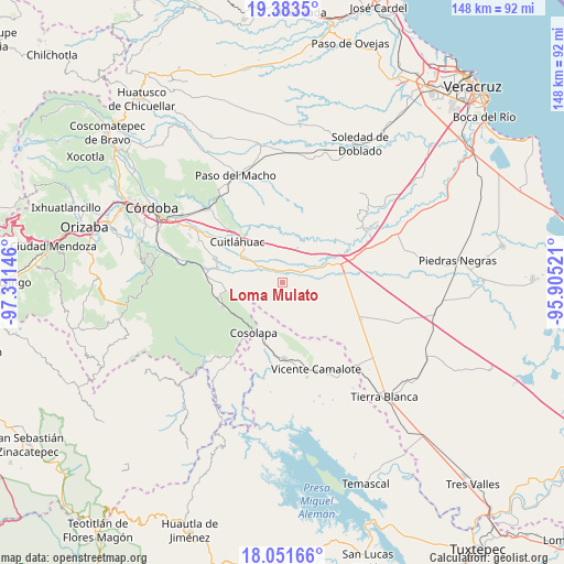
Loma Mulato GPS coordinates[2]
18° 43' 8.004" North, 96° 36' 29.988" West
| Map corner | latitude | longitude |
|---|---|---|
| Upper-left | 19.3835°, | -97.31146° |
| Center: | 18.71889°, | -96.60833° |
| Lower-right: | 18.05166°, | -95.90521° |
| Map W x H: | 148.1×148.1 km | = 92×92mi |
| max Lat: | 32.7° ⇑70% North |
| Loma Mulato: | 18.71889° |
| min Lat: | ⇓30% South 14.53588° |
| min Long | Loma Mulato | max Long |
| -117.105° | -96.60833° | -86.73105° |
| W 79.1%⇐ | ⇒20.9% E |
Elevation
Elevation of Loma Mulato is 204 m = 669 ft, and this is 1049.7 m = 3444 ft below average elevation for this country.
| Max E: |
3497 m = 11473 ft | 75.5% |
| Avg. | 1253.7 m = 4113 ft | |
| Loma Mulato | 204 m = 669 ft | |
Min E: |
-1 m = -3 ft | 24.5% |
See also: Mexico elevation on elevation.city.
Geographical zone
Loma Mulato is located in North Torrid zone (between Equator and Tropic of Cancer). Distance of this Northern Tropic circle is 524.6 km =326 mi to North.| Distance of | km | miles | from Loma Mulato |
|---|---|---|---|
| North Pole | 7925.7 | 4924.8 | to North |
| Arctic Circle | 5319.8 | 3305.6 | to North |
| Tropic Cancer | 524.6 | 326 | to North |
| Equator | 2081.3 | 1293.3 | to South |


Nearby cities:
15 places around Loma Mulato: (largest is in red/bold)
• Bajo Grande
2.6 km =1.6 mi,  324°
324°
• Cerro Alto
11.8 km =7.3 mi,  52°
52°
• Colonia Primero de Mayo
6 km =3.7 mi,  185°
185°
• Cruz Tetela
13 km =8.1 mi,  255°
255°
• El Palmar
11.2 km =7 mi,  327°
327°
• Loma Angosta
10.1 km =6.3 mi, 315°
• Loma del Izote (Mata Planta)
10.6 km =6.6 mi,  177°
177°
• Mata Gallina
11.4 km =7.1 mi,  356°
356°
• Mata Naranjo
12.8 km =8 mi,  300°
300°
• Mata Tenatito (Casco Hacienda)
5.8 km =3.6 mi,  273°
273°
• Palma Sola
11.2 km =7 mi, 189°
• Paso Amapa
8.9 km =5.5 mi,  210°
210°
• Paso Nuevo
13 km =8.1 mi,  165°
165°
• Paso del Rosario
11 km =6.8 mi,  279°
279°
• Río Moreno
6.2 km =3.9 mi,  221°
221°
Sources, notices
• [Note1] Compared only with cities in Mexico existing in our database
• [Src1] Map data: © OpenStreetMap contributors (CC-BY-SA)
• [Src2] Other city data from geonames.org with taken over terms of usage.
• [Src3] Geographical zone / Annual Mean Temperature by Robert A. Rohde @ Wikipedia
