Mata Gallina geodata
Mata Gallina (Veracruz) is a populated place; located in Mexico in America/Mexico_City (GMT-6) time zone. With population of 829 people, there are 10549 cities with bigger population in this country. Compared to other cities in Mexico, 68.4% of cities are located further ↑North; 79.1% of cities are located further ←West and 74.7% of cities have higher elevation than Mata Gallina. Note1


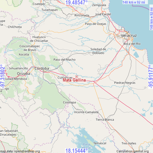
Mata Gallina GPS coordinates[2]
18° 49' 16.572" North, 96° 36' 53.604" West
| Map corner | latitude | longitude |
|---|---|---|
| Upper-left | 19.48547°, | -97.31802° |
| Center: | 18.82127°, | -96.61489° |
| Lower-right: | 18.15444°, | -95.91177° |
| Map W x H: | 148×148 km | = 92×92mi |
| max Lat: | 32.7° ⇑68.4% North |
| Mata Gallina: | 18.82127° |
| min Lat: | ⇓31.6% South 14.53588° |
| min Long | Mata Gallina | max Long |
| -117.105° | -96.61489° | -86.73105° |
| W 79.1%⇐ | ⇒20.9% E |
Elevation
Elevation of Mata Gallina is 231 m = 758 ft, and this is 1022.7 m = 3355 ft below average elevation for this country.
| Max E: |
3497 m = 11473 ft | 74.7% |
| Avg. | 1253.7 m = 4113 ft | |
| Mata Gallina | 231 m = 758 ft | |
Min E: |
-1 m = -3 ft | 25.3% |
See also: Mexico elevation on elevation.city.
Geographical zone
Mata Gallina is located in North Torrid zone (between Equator and Tropic of Cancer). Distance of this Northern Tropic circle is 513.2 km =318.9 mi to North.| Distance of | km | miles | from Mata Gallina |
|---|---|---|---|
| North Pole | 7914.3 | 4917.7 | to North |
| Arctic Circle | 5308.4 | 3298.5 | to North |
| Tropic Cancer | 513.2 | 318.9 | to North |
| Equator | 2092.7 | 1300.3 | to South |


Nearby cities:
15 places around Mata Gallina: (largest is in red/bold)
• Arroyo Azul
7.3 km =4.5 mi,  271°
271°
• Bajo Grande
9.3 km =5.8 mi,  185°
185°
• Cerro Alto
10.8 km =6.7 mi,  112°
112°
• Cuitláhuac
11.4 km =7.1 mi, 266°
• División del Norte (Santa Rosa)
11.9 km =7.4 mi, 274°
• El Maguey
12.6 km =7.8 mi,  275°
275°
• El Palmar
5.7 km =3.5 mi,  249°
249°
• El Tamarindo
13 km =8.1 mi,  264°
264°
• Loma Angosta
7.7 km =4.8 mi,  236°
236°
• Loma Mulato
11.4 km =7.1 mi,  176°
176°
• Mata Naranjo
11.4 km =7.1 mi, 244°
• Mata Tenatito (Casco Hacienda)
12.2 km =7.6 mi,  204°
204°
• Paso Mulato
10.2 km =6.3 mi,  305°
305°
• Paso del Rosario
14 km =8.7 mi,  226°
226°
• San Francisco (Mata Clara)
13.8 km =8.6 mi, 266°
Sources, notices
• [Note1] Compared only with cities in Mexico existing in our database
• [Src1] Map data: © OpenStreetMap contributors (CC-BY-SA)
• [Src2] Other city data from geonames.org with taken over terms of usage.
• [Src3] Geographical zone / Annual Mean Temperature by Robert A. Rohde @ Wikipedia
