San Gabriel geodata
San Gabriel (State of Mexico) is a populated place; located in Mexico in America/Mexico_City (GMT-6) time zone. With population of 688 people, there are 12631 cities with bigger population in this country. Compared to other cities in Mexico, 54.9% of cities are located further ↓South; 59.4% of cities are located further →East and 96.3% of cities have lower elevation than San Gabriel. Note1


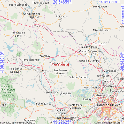
San Gabriel GPS coordinates[2]
19° 53' 19.68" North, 99° 38' 45.816" West
| Map corner | latitude | longitude |
|---|---|---|
| Upper-left | 20.54859°, | -100.34919° |
| Center: | 19.8888°, | -99.64606° |
| Lower-right: | 19.22625°, | -98.94294° |
| Map W x H: | 147×147 km | = 91.3×91.3mi |
| max Lat: | 32.7° ⇑45.1% North |
| San Gabriel: | 19.8888° |
| min Lat: | ⇓54.9% South 14.53588° |
| min Long | San Gabriel | max Long |
| -117.105° | -99.64606° | -86.73105° |
| W 40.6%⇐ | ⇒59.4% E |
Elevation
Elevation of San Gabriel is 2642 m = 8668 ft, and this is 1388.3 m = 4555 ft above average elevation for this country.
| Max E: |
3497 m = 11473 ft | 3.7% |
| San Gabriel | 2642 m 8668 ft | |
| Avg. | 1253.7 m = 4113 ft | |
Min E: |
-1 m = -3 ft | 96.3% |
See also: Mexico elevation on elevation.city.
Geographical zone
San Gabriel is located in North Torrid zone (between Equator and Tropic of Cancer). Distance of this Northern Tropic circle is 394.5 km =245.1 mi to North.| Distance of | km | miles | from San Gabriel |
|---|---|---|---|
| North Pole | 7795.6 | 4844 | to North |
| Arctic Circle | 5189.7 | 3224.7 | to North |
| Tropic Cancer | 394.5 | 245.1 | to North |
| Equator | 2211.4 | 1374.1 | to South |


Nearby cities:
15 places around San Gabriel: (largest is in red/bold)
• Dongu
8 km =5 mi,  129°
129°
• Doxhicho
9.4 km =5.8 mi,  82°
82°
• El Durazno de Cuauhtémoc
5 km =3.1 mi,  57°
57°
• El Magueyal
9.6 km =6 mi,  51°
51°
• El Palmito
4.9 km =3 mi,  310°
310°
• El Puerto
1.3 km =0.8 mi,  212°
212°
• El Rincón
7.6 km =4.7 mi,  356°
356°
• Magueycitos
6.7 km =4.2 mi,  12°
12°
• Primera Manzana del Pueblo de Rincón de Bucio
4.7 km =2.9 mi,  252°
252°
• San Andrés Timilpan
9.3 km =5.8 mi,  261°
261°
• San Felipe Coamango
5.3 km =3.3 mi, 128°
• San Juan Tuxtepec
3.6 km =2.2 mi,  157°
157°
• San Lorenzo Octeyuco
9.3 km =5.8 mi,  30°
30°
• Teupan (Piedras Negras)
7.7 km =4.8 mi,  316°
316°
• Xhimojay
3.7 km =2.3 mi, 6°
Sources, notices
• [Note1] Compared only with cities in Mexico existing in our database
• [Src1] Map data: © OpenStreetMap contributors (CC-BY-SA)
• [Src2] Other city data from geonames.org with taken over terms of usage.
• [Src3] Geographical zone / Annual Mean Temperature by Robert A. Rohde @ Wikipedia
