San Juan Tuxtepec geodata
San Juan Tuxtepec (State of Mexico) is a populated place; located in Mexico in America/Mexico_City (GMT-6) time zone. With population of 4,251 people, there are 2158 cities with bigger population in this country. Compared to other cities in Mexico, 54.2% of cities are located further ↓South; 59.1% of cities are located further →East and 97.9% of cities have lower elevation than San Juan Tuxtepec. Note1


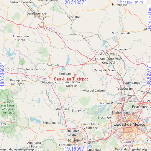
San Juan Tuxtepec GPS coordinates[2]
19° 51' 31.14" North, 99° 37' 58.404" West
| Map corner | latitude | longitude |
|---|---|---|
| Upper-left | 20.51857°, | -100.33602° |
| Center: | 19.85865°, | -99.63289° |
| Lower-right: | 19.19597°, | -98.92977° |
| Map W x H: | 147.1×147.1 km | = 91.4×91.4mi |
| max Lat: | 32.7° ⇑45.8% North |
| San Juan Tuxtepec: | 19.85865° |
| min Lat: | ⇓54.2% South 14.53588° |
| min Long | San Juan Tuxtep | max Long |
| -117.105° | -99.63289° | -86.73105° |
| W 40.9%⇐ | ⇒59.1% E |
Elevation
Elevation of San Juan Tuxtepec is 2734 m = 8970 ft, and this is 1480.3 m = 4857 ft above average elevation for this country.
| Max E: |
3497 m = 11473 ft | 2.1% |
| San Juan Tuxtepec | 2734 m 8970 ft | |
| Avg. | 1253.7 m = 4113 ft | |
Min E: |
-1 m = -3 ft | 97.9% |
See also: Mexico elevation on elevation.city.
Geographical zone
San Juan Tuxtepec is located in North Torrid zone (between Equator and Tropic of Cancer). Distance of this Northern Tropic circle is 397.8 km =247.2 mi to North.| Distance of | km | miles | from San Juan Tuxtepec |
|---|---|---|---|
| North Pole | 7799 | 4846.1 | to North |
| Arctic Circle | 5193.1 | 3226.8 | to North |
| Tropic Cancer | 397.8 | 247.2 | to North |
| Equator | 2208.1 | 1372 | to South |


Nearby cities:
15 places around San Juan Tuxtepec: (largest is in red/bold)
• Barrio Tercero
8.8 km =5.5 mi,  199°
199°
• Cadenqui
7.6 km =4.7 mi,  151°
151°
• Dongu
5.2 km =3.2 mi,  109°
109°
• El Durazno de Cuauhtémoc
6.7 km =4.2 mi,  25°
25°
• El Palmito
8.3 km =5.2 mi,  322°
322°
• El Puerto
3.1 km =1.9 mi, 318°
• La Esperanza
9 km =5.6 mi, 107°
• La Ladera
8.8 km =5.5 mi,  125°
125°
• Primera Manzana del Pueblo de Rincón de Bucio
6.2 km =3.9 mi,  288°
288°
• San Bartolo Morelos
8.9 km =5.5 mi,  205°
205°
• San Felipe Coamango
2.7 km =1.7 mi,  89°
89°
• San Gabriel
3.6 km =2.2 mi,  337°
337°
• Santa María
8.2 km =5.1 mi, 91°
• Xhimojay
7.1 km =4.4 mi,  351°
351°
• Xhinte de Lagos
8.3 km =5.2 mi,  237°
237°
Sources, notices
• [Note1] Compared only with cities in Mexico existing in our database
• [Src1] Map data: © OpenStreetMap contributors (CC-BY-SA)
• [Src2] Other city data from geonames.org with taken over terms of usage.
• [Src3] Geographical zone / Annual Mean Temperature by Robert A. Rohde @ Wikipedia
