San Felipe Coamango geodata
San Felipe Coamango (State of Mexico) is a populated place; located in Mexico in America/Mexico_City (GMT-6) time zone. With population of 4,638 people, there are 1984 cities with bigger population in this country. Compared to other cities in Mexico, 54.3% of cities are located further ↓South; 58.7% of cities are located further →East and 96.7% of cities have lower elevation than San Felipe Coamango. Note1


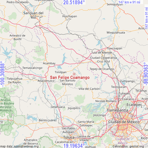
San Felipe Coamango GPS coordinates[2]
19° 51' 32.472" North, 99° 36' 24.3" West
| Map corner | latitude | longitude |
|---|---|---|
| Upper-left | 20.51894°, | -100.30988° |
| Center: | 19.85902°, | -99.60675° |
| Lower-right: | 19.19634°, | -98.90363° |
| Map W x H: | 147.1×147.1 km | = 91.4×91.4mi |
| max Lat: | 32.7° ⇑45.7% North |
| San Felipe Coamango: | 19.85902° |
| min Lat: | ⇓54.3% South 14.53588° |
| min Long | San Felipe Coam | max Long |
| -117.105° | -99.60675° | -86.73105° |
| W 41.3%⇐ | ⇒58.7% E |
Elevation
Elevation of San Felipe Coamango is 2661 m = 8730 ft, and this is 1407.3 m = 4617 ft above average elevation for this country.
| Max E: |
3497 m = 11473 ft | 3.3% |
| San Felipe Coamango | 2661 m 8730 ft | |
| Avg. | 1253.7 m = 4113 ft | |
Min E: |
-1 m = -3 ft | 96.7% |
See also: Mexico elevation on elevation.city.
Geographical zone
San Felipe Coamango is located in North Torrid zone (between Equator and Tropic of Cancer). Distance of this Northern Tropic circle is 397.8 km =247.2 mi to North.| Distance of | km | miles | from San Felipe Coamango |
|---|---|---|---|
| North Pole | 7798.9 | 4846 | to North |
| Arctic Circle | 5193.1 | 3226.8 | to North |
| Tropic Cancer | 397.8 | 247.2 | to North |
| Equator | 2208.1 | 1372 | to South |


Nearby cities:
15 places around San Felipe Coamango: (largest is in red/bold)
• Cadenqui
6.7 km =4.2 mi,  172°
172°
• Chapa de Mota
9.8 km =6.1 mi,  120°
120°
• Dongu
2.8 km =1.7 mi,  130°
130°
• Doxhicho
6.9 km =4.3 mi,  48°
48°
• El Durazno de Cuauhtémoc
6 km =3.7 mi,  1°
1°
• El Magueyal
9.9 km =6.2 mi,  19°
19°
• El Puerto
5.3 km =3.3 mi,  295°
295°
• La Esperanza
6.5 km =4 mi, 115°
• La Ladera
6.8 km =4.2 mi,  139°
139°
• Primera Manzana del Pueblo de Rincón de Bucio
8.8 km =5.5 mi,  282°
282°
• San Gabriel
5.3 km =3.3 mi,  308°
308°
• San Juan Tuxtepec
2.7 km =1.7 mi,  269°
269°
• Santa María
5.4 km =3.4 mi,  92°
92°
• Tenjay
8.1 km =5 mi, 135°
• Xhimojay
7.9 km =4.9 mi,  331°
331°
Sources, notices
• [Note1] Compared only with cities in Mexico existing in our database
• [Src1] Map data: © OpenStreetMap contributors (CC-BY-SA)
• [Src2] Other city data from geonames.org with taken over terms of usage.
• [Src3] Geographical zone / Annual Mean Temperature by Robert A. Rohde @ Wikipedia
