Tlachaloya geodata
Tlachaloya (Morelos) is a populated place; located in Mexico in America/Mexico_City (GMT-6) time zone. With population of 3,563 people, there are 2567 cities with bigger population in this country. Compared to other cities in Mexico, 55.1% of cities are located further ↑North; 59.7% of cities are located further →East and 94.4% of cities have lower elevation than Tlachaloya. Note1


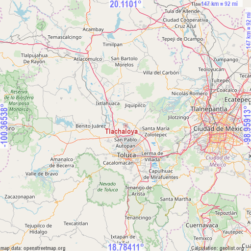
Tlachaloya GPS coordinates[2]
19° 26' 54.456" North, 99° 39' 44.1" West
| Map corner | latitude | longitude |
|---|---|---|
| Upper-left | 20.1101°, | -100.36538° |
| Center: | 19.44846°, | -99.66225° |
| Lower-right: | 18.78411°, | -98.95913° |
| Map W x H: | 147.4×147.4 km | = 91.6×91.6mi |
| max Lat: | 32.7° ⇑55.1% North |
| Tlachaloya: | 19.44846° |
| min Lat: | ⇓44.9% South 14.53588° |
| min Long | Tlachaloya | max Long |
| -117.105° | -99.66225° | -86.73105° |
| W 40.3%⇐ | ⇒59.7% E |
Elevation
Elevation of Tlachaloya is 2583 m = 8474 ft, and this is 1329.3 m = 4361 ft above average elevation for this country.
| Max E: |
3497 m = 11473 ft | 5.6% |
| Tlachaloya | 2583 m 8474 ft | |
| Avg. | 1253.7 m = 4113 ft | |
Min E: |
-1 m = -3 ft | 94.4% |
See also: Mexico elevation on elevation.city.
Geographical zone
Tlachaloya is located in North Torrid zone (between Equator and Tropic of Cancer). Distance of this Northern Tropic circle is 443.5 km =275.6 mi to North.| Distance of | km | miles | from Tlachaloya |
|---|---|---|---|
| North Pole | 7844.6 | 4874.4 | to North |
| Arctic Circle | 5238.7 | 3255.2 | to North |
| Tropic Cancer | 443.5 | 275.6 | to North |
| Equator | 2162.5 | 1343.7 | to South |


Nearby cities:
15 places around Tlachaloya: (largest is in red/bold)
• Barrio de San Carlos
3.6 km =2.2 mi,  238°
238°
• Barrio del Cajón
6.4 km =4 mi,  176°
176°
• Ejido de Dolores
5.5 km =3.4 mi,  110°
110°
• Fraccionamiento Real de San Pablo
6.7 km =4.2 mi,  167°
167°
• Galaxias Toluca
5.7 km =3.5 mi, 167°
• Loma de Progreso
4.5 km =2.8 mi,  122°
122°
• Loma de San Nicolás
6 km =3.7 mi,  98°
98°
• Molino Abajo
6.3 km =3.9 mi,  88°
88°
• San Antonio del Puente
5.8 km =3.6 mi,  125°
125°
• San Diego Alcalá
4.3 km =2.7 mi, 85°
• San José Comalco
4.5 km =2.8 mi,  56°
56°
• San José Pathé
3.6 km =2.2 mi, 114°
• San José la Costa
2.7 km =1.7 mi, 133°
• San José las Lomas
3.5 km =2.2 mi,  345°
345°
• Silverio Galicia García
4.2 km =2.6 mi, 90°
Sources, notices
• [Note1] Compared only with cities in Mexico existing in our database
• [Src1] Map data: © OpenStreetMap contributors (CC-BY-SA)
• [Src2] Other city data from geonames.org with taken over terms of usage.
• [Src3] Geographical zone / Annual Mean Temperature by Robert A. Rohde @ Wikipedia
