San José geodata
San José (Morelos) is a populated place; located in Mexico in America/Mexico_City (GMT-6) time zone. With population of 2,013 people, there are 4320 cities with bigger population in this country. Compared to other cities in Mexico, 64.6% of cities are located further ↑North; 59.7% of cities are located further →East and 91% of cities have lower elevation than San José. Note1


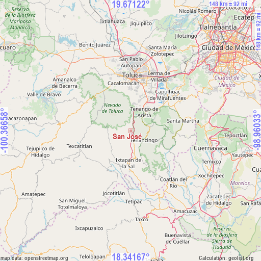
San José GPS coordinates[2]
19° 0' 27.972" North, 99° 39' 48.42" West
| Map corner | latitude | longitude |
|---|---|---|
| Upper-left | 19.67122°, | -100.36658° |
| Center: | 19.00777°, | -99.66345° |
| Lower-right: | 18.34167°, | -98.96033° |
| Map W x H: | 147.8×147.8 km | = 91.8×91.8mi |
| max Lat: | 32.7° ⇑64.6% North |
| San José: | 19.00777° |
| min Lat: | ⇓35.4% South 14.53588° |
| min Long | San José | max Long |
| -117.105° | -99.66345° | -86.73105° |
| W 40.3%⇐ | ⇒59.7% E |
Elevation
Elevation of San José is 2440 m = 8005 ft, and this is 1186.3 m = 3892 ft above average elevation for this country.
| Max E: |
3497 m = 11473 ft | 9% |
| San José | 2440 m 8005 ft | |
| Avg. | 1253.7 m = 4113 ft | |
Min E: |
-1 m = -3 ft | 91% |
See also: Mexico elevation on elevation.city.
Geographical zone
San José is located in North Torrid zone (between Equator and Tropic of Cancer). Distance of this Northern Tropic circle is 492.5 km =306 mi to North.| Distance of | km | miles | from San José |
|---|---|---|---|
| North Pole | 7893.6 | 4904.9 | to North |
| Arctic Circle | 5287.7 | 3285.6 | to North |
| Tropic Cancer | 492.5 | 306 | to North |
| Equator | 2113.5 | 1313.3 | to South |


Nearby cities:
15 places around San José: (largest is in red/bold)
• Cruz Vidriada
2.2 km =1.4 mi,  105°
105°
• El Islote
4.5 km =2.8 mi,  173°
173°
• La Joya
4.1 km =2.5 mi,  164°
164°
• Los Ranchos de San José
3.9 km =2.4 mi,  357°
357°
• San Antonio Agua Bendita
4.2 km =2.6 mi,  99°
99°
• San Bartolomé
1.6 km =1 mi,  276°
276°
• San Diego
1 km =0.6 mi,  86°
86°
• San Lucas
3.3 km =2.1 mi, 174°
• San Mateo Coapexco
5.5 km =3.4 mi,  202°
202°
• San Miguel
1.9 km =1.2 mi,  186°
186°
• San Pedro Tlanixco
6.2 km =3.9 mi,  10°
10°
• Santa Ana Ixtlahuatzingo (Santa Ana)
5.9 km =3.7 mi,  134°
134°
• Santa María Aranzazú (Santa María)
2.6 km =1.6 mi,  147°
147°
• Santiago Oxtotitlán
5.2 km =3.2 mi, 185°
• Villa Guerrero
5.6 km =3.5 mi, 154°
Sources, notices
• [Note1] Compared only with cities in Mexico existing in our database
• [Src1] Map data: © OpenStreetMap contributors (CC-BY-SA)
• [Src2] Other city data from geonames.org with taken over terms of usage.
• [Src3] Geographical zone / Annual Mean Temperature by Robert A. Rohde @ Wikipedia
