Villa Guerrero geodata
Villa Guerrero (State of Mexico) is a seat of a second-order administrative division; located in Mexico in America/Mexico_City (GMT-6) time zone. With population of 9,509 people, there are 1011 cities with bigger population in this country. Compared to other cities in Mexico, 65.5% of cities are located further ↑North; 59.3% of cities are located further →East and 81.3% of cities have lower elevation than Villa Guerrero. Note1


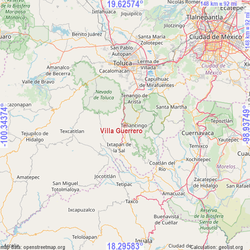
Villa Guerrero GPS coordinates[2]
18° 57' 43.596" North, 99° 38' 26.196" West
| Map corner | latitude | longitude |
|---|---|---|
| Upper-left | 19.62574°, | -100.34374° |
| Center: | 18.96211°, | -99.64061° |
| Lower-right: | 18.29583°, | -98.93749° |
| Map W x H: | 147.9×147.9 km | = 91.9×91.9mi |
| max Lat: | 32.7° ⇑65.5% North |
| Villa Guerrero: | 18.96211° |
| min Lat: | ⇓34.5% South 14.53588° |
| min Long | Villa Guerrero | max Long |
| -117.105° | -99.64061° | -86.73105° |
| W 40.7%⇐ | ⇒59.3% E |
Elevation
Elevation of Villa Guerrero is 2170 m = 7119 ft, and this is 916.3 m = 3006 ft above average elevation for this country.
| Max E: |
3497 m = 11473 ft | 18.7% |
| Villa Guerrero | 2170 m 7119 ft | |
| Avg. | 1253.7 m = 4113 ft | |
Min E: |
-1 m = -3 ft | 81.3% |
See also: Mexico elevation on elevation.city.
Geographical zone
Villa Guerrero is located in North Torrid zone (between Equator and Tropic of Cancer). Distance of this Northern Tropic circle is 497.5 km =309.1 mi to North.| Distance of | km | miles | from Villa Guerrero |
|---|---|---|---|
| North Pole | 7898.7 | 4908 | to North |
| Arctic Circle | 5292.8 | 3288.8 | to North |
| Tropic Cancer | 497.5 | 309.1 | to North |
| Equator | 2108.4 | 1310.1 | to South |


Nearby cities:
15 places around Villa Guerrero: (largest is in red/bold)
• Barrio Santa Teresa
4.1 km =2.5 mi,  84°
84°
• Buenavista
2.5 km =1.6 mi,  223°
223°
• Coxcacoaco
1.6 km =1 mi,  122°
122°
• Ejido de San Mateo Coapexco
1.5 km =0.9 mi,  187°
187°
• El Islote
2 km =1.2 mi,  288°
288°
• Jesús Carranza (Rancho de Jesús)
2.1 km =1.3 mi,  150°
150°
• La Joya
1.7 km =1.1 mi,  312°
312°
• San Felipe
3.5 km =2.2 mi,  204°
204°
• San Francisco
1.6 km =1 mi,  206°
206°
• San Lucas
2.7 km =1.7 mi, 310°
• San Miguel
4.2 km =2.6 mi,  320°
320°
• Santa Ana Ixtlahuatzingo (Santa Ana)
2 km =1.2 mi,  62°
62°
• Santa María Aranzazú (Santa María)
3.1 km =1.9 mi,  340°
340°
• Santiago Oxtotitlán
2.9 km =1.8 mi,  268°
268°
• Tepetzingo
4 km =2.5 mi,  132°
132°
Sources, notices
• [Note1] Compared only with cities in Mexico existing in our database
• [Src1] Map data: © OpenStreetMap contributors (CC-BY-SA)
• [Src2] Other city data from geonames.org with taken over terms of usage.
• [Src3] Geographical zone / Annual Mean Temperature by Robert A. Rohde @ Wikipedia
