La Joya geodata
La Joya (State of Mexico) is a populated place; located in Mexico in America/Mexico_City (GMT-6) time zone. With population of 1,396 people, there are 6199 cities with bigger population in this country. Compared to other cities in Mexico, 65.2% of cities are located further ↑North; 59.5% of cities are located further →East and 84.1% of cities have lower elevation than La Joya. Note1


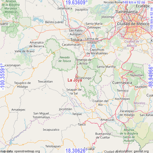
La Joya GPS coordinates[2]
18° 58' 21" North, 99° 39' 10.008" West
| Map corner | latitude | longitude |
|---|---|---|
| Upper-left | 19.63609°, | -100.35591° |
| Center: | 18.9725°, | -99.65278° |
| Lower-right: | 18.30626°, | -98.94966° |
| Map W x H: | 147.9×147.9 km | = 91.9×91.9mi |
| max Lat: | 32.7° ⇑65.2% North |
| La Joya: | 18.9725° |
| min Lat: | ⇓34.8% South 14.53588° |
| min Long | La Joya | max Long |
| -117.105° | -99.65278° | -86.73105° |
| W 40.5%⇐ | ⇒59.5% E |
Elevation
Elevation of La Joya is 2244 m = 7362 ft, and this is 990.3 m = 3249 ft above average elevation for this country.
| Max E: |
3497 m = 11473 ft | 15.9% |
| La Joya | 2244 m 7362 ft | |
| Avg. | 1253.7 m = 4113 ft | |
Min E: |
-1 m = -3 ft | 84.1% |
See also: Mexico elevation on elevation.city.
Geographical zone
La Joya is located in North Torrid zone (between Equator and Tropic of Cancer). Distance of this Northern Tropic circle is 496.4 km =308.4 mi to North.| Distance of | km | miles | from La Joya |
|---|---|---|---|
| North Pole | 7897.5 | 4907.3 | to North |
| Arctic Circle | 5291.6 | 3288 | to North |
| Tropic Cancer | 496.4 | 308.4 | to North |
| Equator | 2109.5 | 1310.8 | to South |


Nearby cities:
15 places around La Joya: (largest is in red/bold)
• Buenavista
3 km =1.9 mi,  188°
188°
• Coxcacoaco
3.3 km =2.1 mi,  127°
127°
• Cruz Vidriada
3.5 km =2.2 mi,  17°
17°
• Ejido de San Mateo Coapexco
2.8 km =1.7 mi,  157°
157°
• El Islote
0.8 km =0.5 mi,  230°
230°
• Jesús Carranza (Rancho de Jesús)
3.8 km =2.4 mi,  142°
142°
• San Diego
4 km =2.5 mi,  357°
357°
• San Francisco
2.6 km =1.6 mi,  167°
167°
• San Lucas
1 km =0.6 mi,  307°
307°
• San Mateo Coapexco
3.4 km =2.1 mi,  249°
249°
• San Miguel
2.5 km =1.6 mi,  326°
326°
• Santa Ana Ixtlahuatzingo (Santa Ana)
3.1 km =1.9 mi,  94°
94°
• Santa María Aranzazú (Santa María)
1.8 km =1.1 mi,  7°
7°
• Santiago Oxtotitlán
2 km =1.2 mi, 232°
• Villa Guerrero
1.7 km =1.1 mi, 132°
Sources, notices
• [Note1] Compared only with cities in Mexico existing in our database
• [Src1] Map data: © OpenStreetMap contributors (CC-BY-SA)
• [Src2] Other city data from geonames.org with taken over terms of usage.
• [Src3] Geographical zone / Annual Mean Temperature by Robert A. Rohde @ Wikipedia
