San Miguel geodata
San Miguel (State of Mexico) is a populated place; located in Mexico in America/Mexico_City (GMT-6) time zone. With population of 1,571 people, there are 5496 cities with bigger population in this country. Compared to other cities in Mexico, 64.9% of cities are located further ↑North; 59.7% of cities are located further →East and 88.3% of cities have lower elevation than San Miguel. Note1


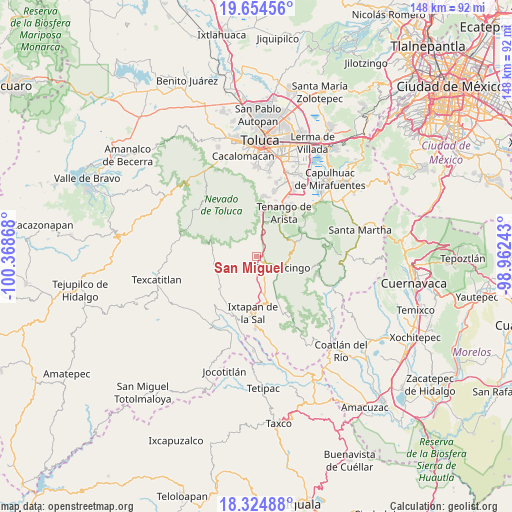
San Miguel GPS coordinates[2]
18° 59' 27.78" North, 99° 39' 55.98" West
| Map corner | latitude | longitude |
|---|---|---|
| Upper-left | 19.65456°, | -100.36868° |
| Center: | 18.99105°, | -99.66555° |
| Lower-right: | 18.32488°, | -98.96243° |
| Map W x H: | 147.8×147.8 km | = 91.8×91.8mi |
| max Lat: | 32.7° ⇑64.9% North |
| San Miguel: | 18.99105° |
| min Lat: | ⇓35.1% South 14.53588° |
| min Long | San Miguel | max Long |
| -117.105° | -99.66555° | -86.73105° |
| W 40.3%⇐ | ⇒59.7% E |
Elevation
Elevation of San Miguel is 2352 m = 7717 ft, and this is 1098.3 m = 3603 ft above average elevation for this country.
| Max E: |
3497 m = 11473 ft | 11.7% |
| San Miguel | 2352 m 7717 ft | |
| Avg. | 1253.7 m = 4113 ft | |
Min E: |
-1 m = -3 ft | 88.3% |
See also: Mexico elevation on elevation.city.
Geographical zone
San Miguel is located in North Torrid zone (between Equator and Tropic of Cancer). Distance of this Northern Tropic circle is 494.3 km =307.1 mi to North.| Distance of | km | miles | from San Miguel |
|---|---|---|---|
| North Pole | 7895.5 | 4906 | to North |
| Arctic Circle | 5289.6 | 3286.8 | to North |
| Tropic Cancer | 494.3 | 307.1 | to North |
| Equator | 2111.6 | 1312.1 | to South |


Nearby cities:
15 places around San Miguel: (largest is in red/bold)
• Buenavista
5.1 km =3.2 mi,  169°
169°
• Cruz Vidriada
2.7 km =1.7 mi,  62°
62°
• El Islote
2.7 km =1.7 mi,  164°
164°
• La Joya
2.5 km =1.6 mi,  146°
146°
• San Antonio Agua Bendita
4.6 km =2.9 mi,  75°
75°
• San Bartolomé
2.5 km =1.6 mi,  326°
326°
• San Diego
2.3 km =1.4 mi,  31°
31°
• San Francisco
5 km =3.1 mi, 157°
• San José
1.9 km =1.2 mi,  6°
6°
• San Lucas
1.5 km =0.9 mi, 160°
• San Mateo Coapexco
3.8 km =2.4 mi,  209°
209°
• Santa Ana Ixtlahuatzingo (Santa Ana)
5 km =3.1 mi,  117°
117°
• Santa María Aranzazú (Santa María)
1.6 km =1 mi,  100°
100°
• Santiago Oxtotitlán
3.3 km =2.1 mi,  184°
184°
• Villa Guerrero
4.2 km =2.6 mi,  140°
140°
Sources, notices
• [Note1] Compared only with cities in Mexico existing in our database
• [Src1] Map data: © OpenStreetMap contributors (CC-BY-SA)
• [Src2] Other city data from geonames.org with taken over terms of usage.
• [Src3] Geographical zone / Annual Mean Temperature by Robert A. Rohde @ Wikipedia
