El Islote geodata
El Islote (State of Mexico) is a populated place; located in Mexico in America/Mexico_City (GMT-6) time zone. With population of 534 people, there are 15868 cities with bigger population in this country. Compared to other cities in Mexico, 65.4% of cities are located further ↑North; 59.6% of cities are located further →East and 82.9% of cities have lower elevation than El Islote. Note1


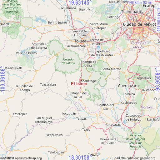
El Islote GPS coordinates[2]
18° 58' 4.224" North, 99° 39' 31.428" West
| Map corner | latitude | longitude |
|---|---|---|
| Upper-left | 19.63145°, | -100.36186° |
| Center: | 18.96784°, | -99.65873° |
| Lower-right: | 18.30158°, | -98.95561° |
| Map W x H: | 147.9×147.9 km | = 91.9×91.9mi |
| max Lat: | 32.7° ⇑65.4% North |
| El Islote: | 18.96784° |
| min Lat: | ⇓34.6% South 14.53588° |
| min Long | El Islote | max Long |
| -117.105° | -99.65873° | -86.73105° |
| W 40.4%⇐ | ⇒59.6% E |
Elevation
Elevation of El Islote is 2212 m = 7257 ft, and this is 958.3 m = 3144 ft above average elevation for this country.
| Max E: |
3497 m = 11473 ft | 17.1% |
| El Islote | 2212 m 7257 ft | |
| Avg. | 1253.7 m = 4113 ft | |
Min E: |
-1 m = -3 ft | 82.9% |
See also: Mexico elevation on elevation.city.
Geographical zone
El Islote is located in North Torrid zone (between Equator and Tropic of Cancer). Distance of this Northern Tropic circle is 496.9 km =308.8 mi to North.| Distance of | km | miles | from El Islote |
|---|---|---|---|
| North Pole | 7898 | 4907.6 | to North |
| Arctic Circle | 5292.1 | 3288.4 | to North |
| Tropic Cancer | 496.9 | 308.8 | to North |
| Equator | 2109 | 1310.5 | to South |


Nearby cities:
15 places around El Islote: (largest is in red/bold)
• Buenavista
2.5 km =1.6 mi,  175°
175°
• Coxcacoaco
3.6 km =2.2 mi,  114°
114°
• Cruz Vidriada
4.2 km =2.6 mi,  23°
23°
• Ejido de San Mateo Coapexco
2.7 km =1.7 mi,  140°
140°
• Jesús Carranza (Rancho de Jesús)
3.9 km =2.4 mi,  130°
130°
• La Joya
0.8 km =0.5 mi,  50°
50°
• San Felipe
3.9 km =2.4 mi,  173°
173°
• San Francisco
2.4 km =1.5 mi,  149°
149°
• San Lucas
1.2 km =0.7 mi,  350°
350°
• San Mateo Coapexco
2.7 km =1.7 mi,  255°
255°
• San Miguel
2.7 km =1.7 mi,  344°
344°
• Santa Ana Ixtlahuatzingo (Santa Ana)
3.7 km =2.3 mi,  85°
85°
• Santa María Aranzazú (Santa María)
2.4 km =1.5 mi, 20°
• Santiago Oxtotitlán
1.2 km =0.7 mi,  234°
234°
• Villa Guerrero
2 km =1.2 mi, 108°
Sources, notices
• [Note1] Compared only with cities in Mexico existing in our database
• [Src1] Map data: © OpenStreetMap contributors (CC-BY-SA)
• [Src2] Other city data from geonames.org with taken over terms of usage.
• [Src3] Geographical zone / Annual Mean Temperature by Robert A. Rohde @ Wikipedia
