San Lucas geodata
San Lucas (State of Mexico) is a populated place; located in Mexico in America/Mexico_City (GMT-6) time zone. With population of 1,551 people, there are 5558 cities with bigger population in this country. Compared to other cities in Mexico, 65.1% of cities are located further ↑North; 59.7% of cities are located further →East and 86% of cities have lower elevation than San Lucas. Note1


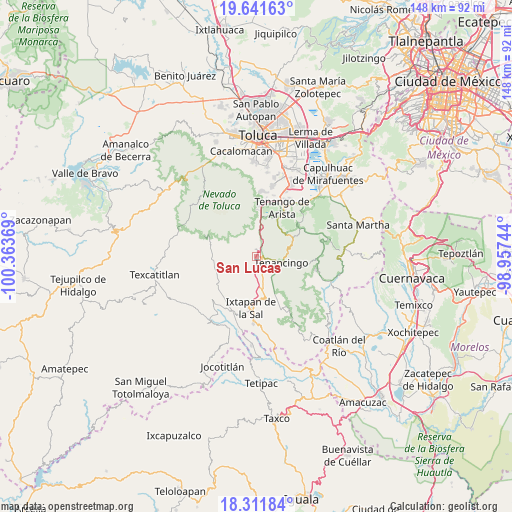
San Lucas GPS coordinates[2]
18° 58' 41.016" North, 99° 39' 38.016" West
| Map corner | latitude | longitude |
|---|---|---|
| Upper-left | 19.64163°, | -100.36369° |
| Center: | 18.97806°, | -99.66056° |
| Lower-right: | 18.31184°, | -98.95744° |
| Map W x H: | 147.9×147.9 km | = 91.9×91.9mi |
| max Lat: | 32.7° ⇑65.1% North |
| San Lucas: | 18.97806° |
| min Lat: | ⇓34.9% South 14.53588° |
| min Long | San Lucas | max Long |
| -117.105° | -99.66056° | -86.73105° |
| W 40.3%⇐ | ⇒59.7% E |
Elevation
Elevation of San Lucas is 2283 m = 7490 ft, and this is 1029.3 m = 3377 ft above average elevation for this country.
| Max E: |
3497 m = 11473 ft | 14% |
| San Lucas | 2283 m 7490 ft | |
| Avg. | 1253.7 m = 4113 ft | |
Min E: |
-1 m = -3 ft | 86% |
See also: Mexico elevation on elevation.city.
Geographical zone
San Lucas is located in North Torrid zone (between Equator and Tropic of Cancer). Distance of this Northern Tropic circle is 495.8 km =308.1 mi to North.| Distance of | km | miles | from San Lucas |
|---|---|---|---|
| North Pole | 7896.9 | 4906.9 | to North |
| Arctic Circle | 5291 | 3287.7 | to North |
| Tropic Cancer | 495.8 | 308.1 | to North |
| Equator | 2110.2 | 1311.2 | to South |


Nearby cities:
15 places around San Lucas: (largest is in red/bold)
• Buenavista
3.6 km =2.2 mi,  173°
173°
• Cruz Vidriada
3.3 km =2.1 mi,  34°
34°
• Ejido de San Mateo Coapexco
3.8 km =2.4 mi,  149°
149°
• El Islote
1.2 km =0.7 mi, 170°
• La Joya
1 km =0.6 mi,  127°
127°
• San Bartolomé
4 km =2.5 mi,  331°
331°
• San Diego
3.4 km =2.1 mi,  10°
10°
• San Francisco
3.5 km =2.2 mi,  156°
156°
• San José
3.3 km =2.1 mi,  354°
354°
• San Mateo Coapexco
3 km =1.9 mi,  232°
232°
• San Miguel
1.5 km =0.9 mi,  340°
340°
• Santa Ana Ixtlahuatzingo (Santa Ana)
4 km =2.5 mi,  102°
102°
• Santa María Aranzazú (Santa María)
1.6 km =1 mi,  42°
42°
• Santiago Oxtotitlán
2 km =1.2 mi,  203°
203°
• Villa Guerrero
2.7 km =1.7 mi, 130°
Sources, notices
• [Note1] Compared only with cities in Mexico existing in our database
• [Src1] Map data: © OpenStreetMap contributors (CC-BY-SA)
• [Src2] Other city data from geonames.org with taken over terms of usage.
• [Src3] Geographical zone / Annual Mean Temperature by Robert A. Rohde @ Wikipedia
