San Pedro Ocotlán geodata
San Pedro Ocotlán (Zacatecas) is a populated place; located in Mexico in America/Mexico_City (GMT-6) time zone. With population of 828 people, there are 10560 cities with bigger population in this country. Compared to other cities in Mexico, 81.6% of cities are located further ↓South; 87.2% of cities are located further →East and 68.6% of cities have lower elevation than San Pedro Ocotlán. Note1


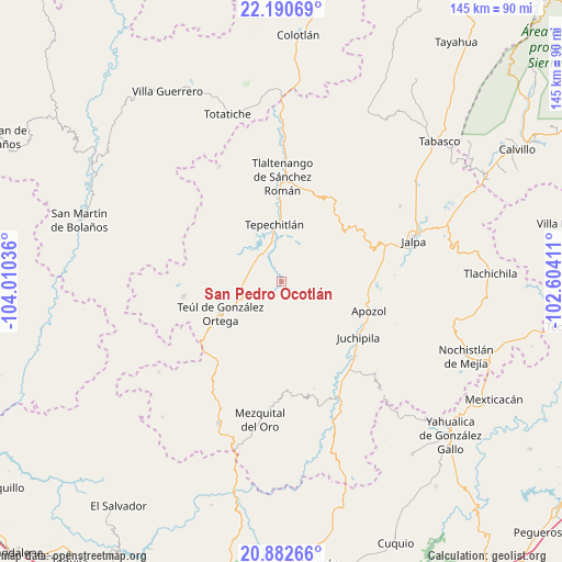
San Pedro Ocotlán GPS coordinates[2]
21° 32' 17.34" North, 103° 18' 26.028" West
| Map corner | latitude | longitude |
|---|---|---|
| Upper-left | 22.19069°, | -104.01036° |
| Center: | 21.53815°, | -103.30723° |
| Lower-right: | 20.88266°, | -102.60411° |
| Map W x H: | 145.4×145.4 km | = 90.3×90.3mi |
| max Lat: | 32.7° ⇑18.4% North |
| San Pedro Ocotlán: | 21.53815° |
| min Lat: | ⇓81.6% South 14.53588° |
| min Long | San Pedro Ocotl | max Long |
| -117.105° | -103.30723° | -86.73105° |
| W 12.8%⇐ | ⇒87.2% E |
Elevation
Elevation of San Pedro Ocotlán is 1899 m = 6230 ft, and this is 645.3 m = 2117 ft above average elevation for this country.
| Max E: |
3497 m = 11473 ft | 31.4% |
| San Pedro Ocotlán | 1899 m 6230 ft | |
| Avg. | 1253.7 m = 4113 ft | |
Min E: |
-1 m = -3 ft | 68.6% |
See also: Mexico elevation on elevation.city.
Geographical zone
San Pedro Ocotlán is located in North Torrid zone (between Equator and Tropic of Cancer). Distance of this Northern Tropic circle is 211.1 km =131.2 mi to North.| Distance of | km | miles | from San Pedro Ocotlán |
|---|---|---|---|
| North Pole | 7612.2 | 4730 | to North |
| Arctic Circle | 5006.4 | 3110.8 | to North |
| Tropic Cancer | 211.1 | 131.2 | to North |
| Equator | 2394.8 | 1488.1 | to South |


Nearby cities:
15 places around San Pedro Ocotlán: (largest is in red/bold)
• Apozol
23.7 km =14.7 mi,  108°
108°
• Bonifacio Falcón
23.3 km =14.5 mi,  127°
127°
• Cicacalco
19.8 km =12.3 mi,  358°
358°
• Cuxpala
28.9 km =18 mi,  163°
163°
• El Remolino
27 km =16.8 mi,  135°
135°
• Florencia
25.8 km =16 mi,  261°
261°
• Fraccionamiento Santo Santiago
27.4 km =17 mi,  7°
7°
• Juchipila
24.4 km =15.2 mi, 126°
• Los Llamas
22.8 km =14.2 mi,  99°
99°
• San José (San José de los Meléndez)
22.9 km =14.2 mi,  124°
124°
• Santa María de la Paz
10.8 km =6.7 mi,  254°
254°
• Talesteipa
18.2 km =11.3 mi, 358°
• Tepechitlán
14.9 km =9.3 mi,  352°
352°
• Teúl de González Ortega
18 km =11.2 mi,  242°
242°
• Tlaltenango de Sánchez Román
27.1 km =16.8 mi,  0°
0°
Sources, notices
• [Note1] Compared only with cities in Mexico existing in our database
• [Src1] Map data: © OpenStreetMap contributors (CC-BY-SA)
• [Src2] Other city data from geonames.org with taken over terms of usage.
• [Src3] Geographical zone / Annual Mean Temperature by Robert A. Rohde @ Wikipedia
