Tepechitlán geodata
Tepechitlán (Zacatecas) is a seat of a second-order administrative division; located in Mexico in America/Mexico_City (GMT-6) time zone. With population of 4,600 people, there are 2000 cities with bigger population in this country. Compared to other cities in Mexico, 82.2% of cities are located further ↓South; 87.3% of cities are located further →East and 59.6% of cities have lower elevation than Tepechitlán. Note1


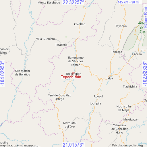
Tepechitlán GPS coordinates[2]
21° 40' 14.268" North, 103° 19' 35.04" West
| Map corner | latitude | longitude |
|---|---|---|
| Upper-left | 22.32257°, | -104.02953° |
| Center: | 21.67063°, | -103.3264° |
| Lower-right: | 21.01573°, | -102.62328° |
| Map W x H: | 145.3×145.3 km | = 90.3×90.3mi |
| max Lat: | 32.7° ⇑17.8% North |
| Tepechitlán: | 21.67063° |
| min Lat: | ⇓82.2% South 14.53588° |
| min Long | Tepechitlán | max Long |
| -117.105° | -103.3264° | -86.73105° |
| W 12.7%⇐ | ⇒87.3% E |
Elevation
Elevation of Tepechitlán is 1719 m = 5640 ft, and this is 465.3 m = 1527 ft above average elevation for this country.
| Max E: |
3497 m = 11473 ft | 40.4% |
| Tepechitlán | 1719 m 5640 ft | |
| Avg. | 1253.7 m = 4113 ft | |
Min E: |
-1 m = -3 ft | 59.6% |
See also: Mexico elevation on elevation.city.
Geographical zone
Tepechitlán is located in North Torrid zone (between Equator and Tropic of Cancer). Distance of this Northern Tropic circle is 196.4 km =122 mi to North.| Distance of | km | miles | from Tepechitlán |
|---|---|---|---|
| North Pole | 7597.5 | 4720.9 | to North |
| Arctic Circle | 4991.6 | 3101.6 | to North |
| Tropic Cancer | 196.4 | 122 | to North |
| Equator | 2409.5 | 1497.2 | to South |


Nearby cities:
15 places around Tepechitlán: (largest is in red/bold)
• Apozol
33.1 km =20.6 mi,  132°
132°
• Atolinga
20.8 km =12.9 mi,  316°
316°
• Cicacalco
5.2 km =3.2 mi,  15°
15°
• Florencia
29.9 km =18.6 mi,  231°
231°
• Fraccionamiento Santo Santiago
13.7 km =8.5 mi, 24°
• Guadalupe Victoria
32.9 km =20.4 mi,  81°
81°
• Los Llamas
30.7 km =19.1 mi, 127°
• Momax
28.1 km =17.5 mi,  2°
2°
• San Pedro Ocotlán
14.9 km =9.3 mi,  172°
172°
• Santa María de la Paz
19.5 km =12.1 mi,  205°
205°
• Talesteipa
3.8 km =2.4 mi, 22°
• Tepizuac
32.7 km =20.3 mi,  261°
261°
• Teúl de González Ortega
26.9 km =16.7 mi, 211°
• Tlaltenango de Sánchez Román
12.6 km =7.8 mi,  11°
11°
• Totatiche
31.1 km =19.3 mi,  337°
337°
Sources, notices
• [Note1] Compared only with cities in Mexico existing in our database
• [Src1] Map data: © OpenStreetMap contributors (CC-BY-SA)
• [Src2] Other city data from geonames.org with taken over terms of usage.
• [Src3] Geographical zone / Annual Mean Temperature by Robert A. Rohde @ Wikipedia
