Piedra Gorda geodata
Piedra Gorda (Zacatecas) is a populated place; located in Mexico in America/Mexico_City (GMT-6) time zone. With population of 1,007 people, there are 8660 cities with bigger population in this country. Compared to other cities in Mexico, 86.7% of cities are located further ↓South; 83.1% of cities are located further →East and 77% of cities have lower elevation than Piedra Gorda. Note1


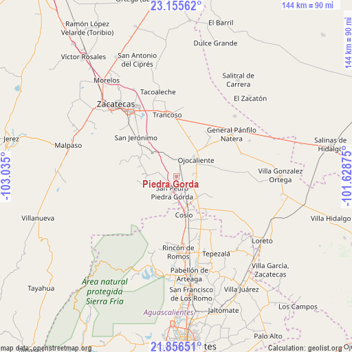
Piedra Gorda GPS coordinates[2]
22° 30' 27.324" North, 102° 19' 54.732" West
| Map corner | latitude | longitude |
|---|---|---|
| Upper-left | 23.15562°, | -103.035° |
| Center: | 22.50759°, | -102.33187° |
| Lower-right: | 21.85651°, | -101.62875° |
| Map W x H: | 144.4×144.4 km | = 89.7×89.7mi |
| max Lat: | 32.7° ⇑13.3% North |
| Piedra Gorda: | 22.50759° |
| min Lat: | ⇓86.7% South 14.53588° |
| min Long | Piedra Gorda | max Long |
| -117.105° | -102.33187° | -86.73105° |
| W 16.9%⇐ | ⇒83.1% E |
Elevation
Elevation of Piedra Gorda is 2069 m = 6788 ft, and this is 815.3 m = 2675 ft above average elevation for this country.
| Max E: |
3497 m = 11473 ft | 23% |
| Piedra Gorda | 2069 m 6788 ft | |
| Avg. | 1253.7 m = 4113 ft | |
Min E: |
-1 m = -3 ft | 77% |
See also: Mexico elevation on elevation.city.
Geographical zone
Piedra Gorda is located in North Torrid zone (between Equator and Tropic of Cancer). Distance of this Northern Tropic circle is 103.3 km =64.2 mi to North.| Distance of | km | miles | from Piedra Gorda |
|---|---|---|---|
| North Pole | 7504.5 | 4663.1 | to North |
| Arctic Circle | 4898.6 | 3043.8 | to North |
| Tropic Cancer | 103.3 | 64.2 | to North |
| Equator | 2502.6 | 1555 | to South |


Nearby cities:
15 places around Piedra Gorda: (largest is in red/bold)
• Colonia Hidalgo
9.6 km =6 mi,  90°
90°
• Colonia Río Verde
10.8 km =6.7 mi,  249°
249°
• Colonia Veinte de Noviembre
5.2 km =3.2 mi,  96°
96°
• El Refugio
12 km =7.5 mi,  2°
2°
• El Salero
13.4 km =8.3 mi,  176°
176°
• Esteban S. Castorena
8.9 km =5.5 mi,  124°
124°
• Genaro Codina
13.1 km =8.1 mi,  260°
260°
• La Concepción
6.8 km =4.2 mi,  82°
82°
• Los Griegos
13.3 km =8.3 mi, 119°
• Luis Moya
12 km =7.5 mi,  134°
134°
• Rancho Nuevo
11.2 km =7 mi,  188°
188°
• San Pedro Piedra Gorda
6.9 km =4.3 mi, 194°
• Soledad de Abajo
12 km =7.5 mi,  156°
156°
• Soledad de Arriba
8.7 km =5.4 mi, 163°
• Tlacotes
7.4 km =4.6 mi,  358°
358°
Sources, notices
• [Note1] Compared only with cities in Mexico existing in our database
• [Src1] Map data: © OpenStreetMap contributors (CC-BY-SA)
• [Src2] Other city data from geonames.org with taken over terms of usage.
• [Src3] Geographical zone / Annual Mean Temperature by Robert A. Rohde @ Wikipedia
