Genaro Codina geodata
Genaro Codina (Zacatecas) is a seat of a second-order administrative division; located in Mexico in America/Mexico_City (GMT-6) time zone. With population of 1,479 people, there are 5833 cities with bigger population in this country. Compared to other cities in Mexico, 86.6% of cities are located further ↓South; 83.8% of cities are located further →East and 80.9% of cities have lower elevation than Genaro Codina. Note1


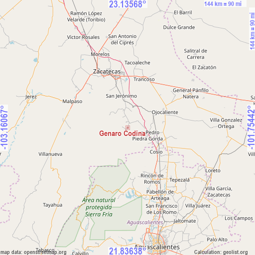
Genaro Codina GPS coordinates[2]
22° 29' 15.18" North, 102° 27' 27.144" West
| Map corner | latitude | longitude |
|---|---|---|
| Upper-left | 23.13568°, | -103.16067° |
| Center: | 22.48755°, | -102.45754° |
| Lower-right: | 21.83638°, | -101.75442° |
| Map W x H: | 144.5×144.5 km | = 89.8×89.8mi |
| max Lat: | 32.7° ⇑13.4% North |
| Genaro Codina: | 22.48755° |
| min Lat: | ⇓86.6% South 14.53588° |
| min Long | Genaro Codina | max Long |
| -117.105° | -102.45754° | -86.73105° |
| W 16.2%⇐ | ⇒83.8% E |
Elevation
Elevation of Genaro Codina is 2162 m = 7093 ft, and this is 908.3 m = 2980 ft above average elevation for this country.
| Max E: |
3497 m = 11473 ft | 19.1% |
| Genaro Codina | 2162 m 7093 ft | |
| Avg. | 1253.7 m = 4113 ft | |
Min E: |
-1 m = -3 ft | 80.9% |
See also: Mexico elevation on elevation.city.
Geographical zone
Genaro Codina is located in North Torrid zone (between Equator and Tropic of Cancer). Distance of this Northern Tropic circle is 105.5 km =65.6 mi to North.| Distance of | km | miles | from Genaro Codina |
|---|---|---|---|
| North Pole | 7506.7 | 4664.4 | to North |
| Arctic Circle | 4900.8 | 3045.2 | to North |
| Tropic Cancer | 105.5 | 65.6 | to North |
| Equator | 2500.4 | 1553.7 | to South |


Nearby cities:
15 places around Genaro Codina: (largest is in red/bold)
• Bañuelos
19.1 km =11.9 mi,  341°
341°
• Colonia Río Verde
3.2 km =2 mi,  118°
118°
• Colonia San Isidro
1.7 km =1.1 mi,  222°
222°
• Colonia Veinte de Noviembre
18.1 km =11.2 mi,  84°
84°
• El Refugio
19.6 km =12.2 mi,  43°
43°
• El Salero
17.8 km =11.1 mi,  128°
128°
• Paso de Méndez
3.4 km =2.1 mi, 338°
• Perales
11.6 km =7.2 mi,  301°
301°
• Piedra Gorda
13.1 km =8.1 mi, 80°
• Rancho Nuevo
14.3 km =8.9 mi, 128°
• San Jerónimo
18.8 km =11.7 mi,  349°
349°
• San Pedro Piedra Gorda
12 km =7.5 mi,  111°
111°
• Santa Inés
6.7 km =4.2 mi,  332°
332°
• Soledad de Arriba
16.6 km =10.3 mi, 111°
• Tlacotes
15.9 km =9.9 mi,  52°
52°
Sources, notices
• [Note1] Compared only with cities in Mexico existing in our database
• [Src1] Map data: © OpenStreetMap contributors (CC-BY-SA)
• [Src2] Other city data from geonames.org with taken over terms of usage.
• [Src3] Geographical zone / Annual Mean Temperature by Robert A. Rohde @ Wikipedia
